Cardeñosa geodata
Cardeñosa (Castille and León) is a seat of a third-order administrative division; located in Spain in Europe/Madrid (GMT+2) time zone. With population of 532 people, there are 3784 cities with bigger population in this country. Compared to other cities in Spain, 57.3% of cities are located further ↑North; 69.1% of cities are located further →East and 93.6% of cities have lower elevation than Cardeñosa. Note1
Administrative division(s):
- Level 1: Castille and León
- Level 2: Provincia de Ávila
- Level 3: Cardeñosa


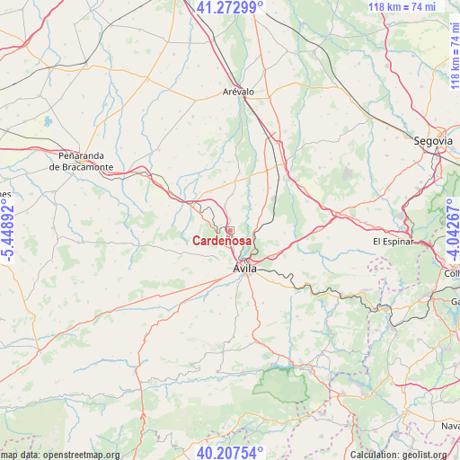
Cardeñosa GPS coordinates[2]
40° 44' 32.64" North, 4° 44' 44.844" West
| Map corner | latitude | longitude |
|---|---|---|
| Upper-left | 41.27299°, | -5.44892° |
| Center: | 40.7424°, | -4.74579° |
| Lower-right: | 40.20754°, | -4.04267° |
| Map W x H: | 118.5×118.5 km | = 73.6×73.6mi |
| max Lat: | 43.74134° ⇑57.3% North |
| Cardeñosa: | 40.7424° |
| min Lat: | ⇓42.7% South 27.64134° |
| min Long | Cardeñosa | max Long |
| -18.00367° | -4.74579° | 4.2899° |
| W 30.9%⇐ | ⇒69.1% E |
Elevation
Elevation of Cardeñosa is 1108 m = 3635 ft, and this is 510 m = 1673 ft above average elevation for this country.
| Max E: |
1682 m = 5518 ft | 6.4% |
| Cardeñosa | 1108 m 3635 ft | |
| Avg. | 598 m = 1962 ft | |
Min E: |
0 m = 0 ft | 93.6% |
See also: Spain elevation on elevation.city.
Geographical zone
Cardeñosa is located in North temperate zone (between Tropic of Cancer and the Arctic Circle). Distance of this Northern Tropic circle is 1924.2 km =1195.6 mi to South.| Distance of | km | miles | from Cardeñosa |
|---|---|---|---|
| North Pole | 5476.9 | 3403.2 | to North |
| Arctic Circle | 2871 | 1784 | to North |
| Tropic Cancer | 1924.2 | 1195.6 | to South |
| Equator | 4530.1 | 2814.9 | to South |


Nearby cities:
15 places around Cardeñosa: (largest is in red/bold)
• Aveinte
8.8 km =5.5 mi,  300°
300°
• Gotarrendura
9.4 km =5.8 mi,  2°
2°
• Hernansancho
12.9 km =8 mi,  5°
5°
• Martiherrero
8.2 km =5.1 mi,  201°
201°
• Mingorría
6.8 km =4.2 mi,  81°
81°
• Monsalupe
4.2 km =2.6 mi,  315°
315°
• Muñopepe
13.5 km =8.4 mi,  207°
207°
• Peñalba de Ávila
3.4 km =2.1 mi,  359°
359°
• Pozanco
9.3 km =5.8 mi,  45°
45°
• San Esteban de los Patos
10.3 km =6.4 mi,  87°
87°
• San Juan de la Encinilla
12.6 km =7.8 mi, 321°
• San Pedro del Arroyo
12.4 km =7.7 mi, 302°
• Santo Domingo de las Posadas
12.2 km =7.6 mi, 50°
• Villaflor
10.9 km =6.8 mi,  279°
279°
• Ávila
10.2 km =6.3 mi,  157°
157°
Sources, notices
• [Note1] Compared only with cities in Spain existing in our database
• [Src1] Map data: © OpenStreetMap contributors (CC-BY-SA)
• [Src2] Other city data from geonames.org with taken over terms of usage.
• [Src3] Geographical zone / Annual Mean Temperature by Robert A. Rohde @ Wikipedia
