Villacarriedo geodata
Villacarriedo (Cantabria) is a seat of a third-order administrative division; located in Spain in Europe/Madrid (GMT+2) time zone. With population of 1,711 people, there are 2329 cities with bigger population in this country. Compared to other cities in Spain, 96.7% of cities are located further ↓South; 56.9% of cities are located further →East and 81% of cities have higher elevation than Villacarriedo. Note1
Administrative division(s):
- Level 1: Cantabria
- Level 2: Provincia de Cantabria
- Level 3: Villacarriedo


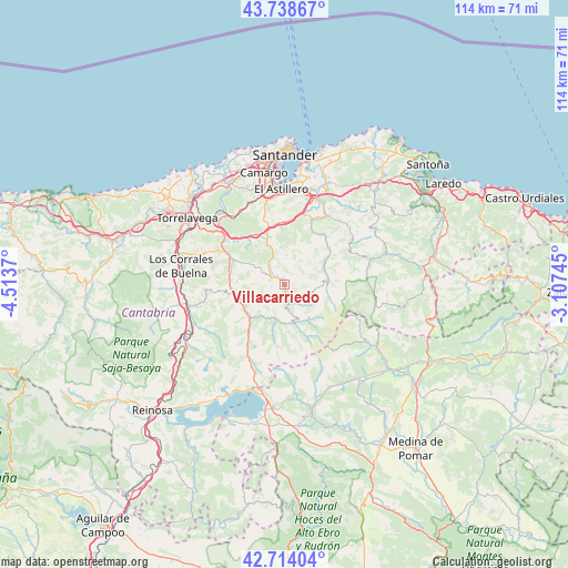
Villacarriedo GPS coordinates[2]
43° 13' 42.636" North, 3° 48' 38.052" West
| Map corner | latitude | longitude |
|---|---|---|
| Upper-left | 43.73867°, | -4.5137° |
| Center: | 43.22851°, | -3.81057° |
| Lower-right: | 42.71404°, | -3.10745° |
| Map W x H: | 113.9×113.9 km | = 70.8×70.8mi |
| max Lat: | 43.74134° ⇑3.3% North |
| Villacarriedo: | 43.22851° |
| min Lat: | ⇓96.7% South 27.64134° |
| min Long | Villacarriedo | max Long |
| -18.00367° | -3.81057° | 4.2899° |
| W 43.1%⇐ | ⇒56.9% E |
Elevation
Elevation of Villacarriedo is 204 m = 669 ft, and this is 394 m = 1293 ft below average elevation for this country.
| Max E: |
1682 m = 5518 ft | 81% |
| Avg. | 598 m = 1962 ft | |
| Villacarriedo | 204 m = 669 ft | |
Min E: |
0 m = 0 ft | 19% |
See also: Spain elevation on elevation.city.
Geographical zone
Villacarriedo is located in North temperate zone (between Tropic of Cancer and the Arctic Circle). Distance of this Northern Tropic circle is 2200.6 km =1367.4 mi to South.| Distance of | km | miles | from Villacarriedo |
|---|---|---|---|
| North Pole | 5200.5 | 3231.4 | to North |
| Arctic Circle | 2594.6 | 1612.2 | to North |
| Tropic Cancer | 2200.6 | 1367.4 | to South |
| Equator | 4806.6 | 2986.7 | to South |


Nearby cities:
15 places around Villacarriedo: (largest is in red/bold)
• Arenas de Iguña
19.8 km =12.3 mi,  255°
255°
• Arredondo
17.7 km =11 mi,  73°
73°
• El Astillero
19.2 km =11.9 mi,  357°
357°
• Entrambasaguas
19.7 km =12.2 mi,  32°
32°
• Liérganes
14.1 km =8.8 mi,  21°
21°
• Penagos
13.8 km =8.6 mi, 358°
• Puente Viesgo
14.9 km =9.3 mi,  301°
301°
• San Pedro del Romeral
12.6 km =7.8 mi,  182°
182°
• Santa María de Cayón
9.1 km =5.7 mi,  346°
346°
• Santiurde de Toranzo
10.5 km =6.5 mi,  275°
275°
• Saro
4.3 km =2.7 mi,  322°
322°
• Selaya
1.7 km =1.1 mi,  166°
166°
• Vega de Pas
8.3 km =5.2 mi,  164°
164°
• Villafufre
7.9 km =4.9 mi, 301°
• Villanueva de Villaescusa
16 km =9.9 mi,  344°
344°
Sources, notices
• [Note1] Compared only with cities in Spain existing in our database
• [Src1] Map data: © OpenStreetMap contributors (CC-BY-SA)
• [Src2] Other city data from geonames.org with taken over terms of usage.
• [Src3] Geographical zone / Annual Mean Temperature by Robert A. Rohde @ Wikipedia
