Vega de Pas geodata
Vega de Pas (Cantabria) is a seat of a third-order administrative division; located in Spain in Europe/Madrid (GMT+2) time zone. With population of 947 people, there are 3017 cities with bigger population in this country. Compared to other cities in Spain, 96% of cities are located further ↓South; 56.5% of cities are located further →East and 71.9% of cities have higher elevation than Vega de Pas. Note1


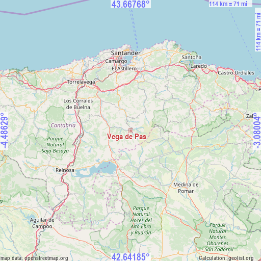
Vega de Pas GPS coordinates[2]
43° 9' 24.912" North, 3° 46' 59.376" West
| Map corner | latitude | longitude |
|---|---|---|
| Upper-left | 43.66768°, | -4.48629° |
| Center: | 43.15692°, | -3.78316° |
| Lower-right: | 42.64185°, | -3.08004° |
| Map W x H: | 114.1×114.1 km | = 70.9×70.9mi |
| max Lat: | 43.74134° ⇑4% North |
| Vega de Pas: | 43.15692° |
| min Lat: | ⇓96% South 27.64134° |
| min Long | Vega de Pas | max Long |
| -18.00367° | -3.78316° | 4.2899° |
| W 43.5%⇐ | ⇒56.5% E |
Elevation
Elevation of Vega de Pas is 349 m = 1145 ft, and this is 249 m = 817 ft below average elevation for this country.
| Max E: |
1682 m = 5518 ft | 71.9% |
| Avg. | 598 m = 1962 ft | |
| Vega de Pas | 349 m = 1145 ft | |
Min E: |
0 m = 0 ft | 28.1% |
See also: Spain elevation on elevation.city.
Geographical zone
Vega de Pas is located in North temperate zone (between Tropic of Cancer and the Arctic Circle). Distance of this Northern Tropic circle is 2192.7 km =1362.5 mi to South.| Distance of | km | miles | from Vega de Pas |
|---|---|---|---|
| North Pole | 5208.5 | 3236.4 | to North |
| Arctic Circle | 2602.6 | 1617.2 | to North |
| Tropic Cancer | 2192.7 | 1362.5 | to South |
| Equator | 4798.6 | 2981.7 | to South |


Nearby cities:
15 places around Vega de Pas: (largest is in red/bold)
• Arenas de Iguña
21.6 km =13.4 mi,  277°
277°
• Arija
22.4 km =13.9 mi,  215°
215°
• Arredondo
19.7 km =12.2 mi,  48°
48°
• Espinosa de los Monteros
20.6 km =12.8 mi,  115°
115°
• Liérganes
21.2 km =13.2 mi,  7°
7°
• Molledo
21 km =13 mi,  267°
267°
• Penagos
21.9 km =13.6 mi,  353°
353°
• Puente Viesgo
21.7 km =13.5 mi,  316°
316°
• San Pedro del Romeral
5.5 km =3.4 mi,  211°
211°
• Santa María de Cayón
17.4 km =10.8 mi, 345°
• Santiurde de Toranzo
15.6 km =9.7 mi,  305°
305°
• Saro
12.4 km =7.7 mi,  337°
337°
• Selaya
6.6 km =4.1 mi, 343°
• Villacarriedo
8.3 km =5.2 mi, 344°
• Villafufre
15 km =9.3 mi, 323°
Sources, notices
• [Note1] Compared only with cities in Spain existing in our database
• [Src1] Map data: © OpenStreetMap contributors (CC-BY-SA)
• [Src2] Other city data from geonames.org with taken over terms of usage.
• [Src3] Geographical zone / Annual Mean Temperature by Robert A. Rohde @ Wikipedia
