Puente Viesgo geodata
Puente Viesgo (Cantabria) is a seat of a third-order administrative division; located in Spain in Europe/Madrid (GMT+2) time zone. With population of 2,558 people, there are 1882 cities with bigger population in this country. Compared to other cities in Spain, 97.6% of cities are located further ↓South; 59.2% of cities are located further →East and 88.8% of cities have higher elevation than Puente Viesgo. Note1
Administrative division(s):
- Level 1: Cantabria
- Level 2: Provincia de Cantabria
- Level 3: Puente Viesgo


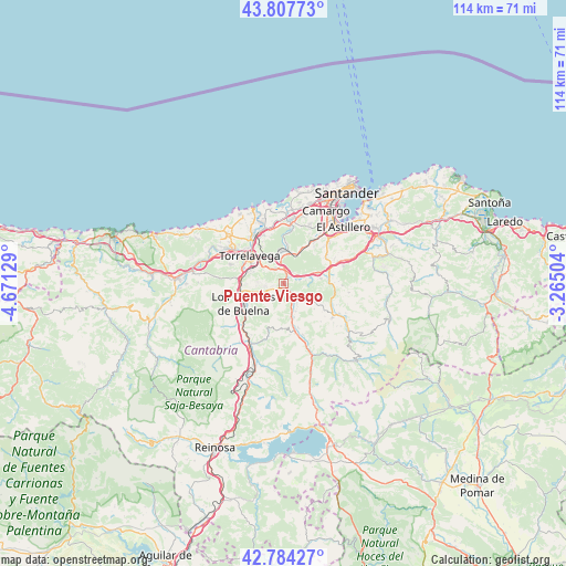
Puente Viesgo GPS coordinates[2]
43° 17' 53.34" North, 3° 58' 5.412" West
| Map corner | latitude | longitude |
|---|---|---|
| Upper-left | 43.80773°, | -4.67129° |
| Center: | 43.29815°, | -3.96817° |
| Lower-right: | 42.78427°, | -3.26504° |
| Map W x H: | 113.8×113.8 km | = 70.7×70.7mi |
| max Lat: | 43.74134° ⇑2.4% North |
| Puente Viesgo: | 43.29815° |
| min Lat: | ⇓97.6% South 27.64134° |
| min Long | Puente Viesgo | max Long |
| -18.00367° | -3.96817° | 4.2899° |
| W 40.8%⇐ | ⇒59.2% E |
Elevation
Elevation of Puente Viesgo is 83 m = 272 ft, and this is 515 m = 1690 ft below average elevation for this country.
| Max E: |
1682 m = 5518 ft | 88.8% |
| Avg. | 598 m = 1962 ft | |
| Puente Viesgo | 83 m = 272 ft | |
Min E: |
0 m = 0 ft | 11.2% |
See also: Spain elevation on elevation.city.
Geographical zone
Puente Viesgo is located in North temperate zone (between Tropic of Cancer and the Arctic Circle). Distance of this Northern Tropic circle is 2208.4 km =1372.2 mi to South.| Distance of | km | miles | from Puente Viesgo |
|---|---|---|---|
| North Pole | 5192.8 | 3226.7 | to North |
| Arctic Circle | 2586.9 | 1607.4 | to North |
| Tropic Cancer | 2208.4 | 1372.2 | to South |
| Equator | 4814.3 | 2991.5 | to South |


Nearby cities:
15 places around Puente Viesgo: (largest is in red/bold)
• Arenas de Iguña
14.3 km =8.9 mi,  206°
206°
• Camargo
13.9 km =8.6 mi,  28°
28°
• Cartes
8.7 km =5.4 mi,  290°
290°
• Los Corrales de Buelna
9.3 km =5.8 mi,  245°
245°
• Miengo
14.7 km =9.1 mi,  350°
350°
• Penagos
13.9 km =8.6 mi,  64°
64°
• Polanco
10.4 km =6.5 mi,  338°
338°
• Reocín
11.2 km =7 mi, 294°
• Santa María de Cayón
10.7 km =6.6 mi,  83°
83°
• Santiurde de Toranzo
7.1 km =4.4 mi,  160°
160°
• Saro
11 km =6.8 mi,  112°
112°
• Torrelavega
8.6 km =5.3 mi,  311°
311°
• Villacarriedo
14.9 km =9.3 mi,  121°
121°
• Villafufre
7 km =4.3 mi, 121°
• Villanueva de Villaescusa
11.5 km =7.1 mi,  47°
47°
Sources, notices
• [Note1] Compared only with cities in Spain existing in our database
• [Src1] Map data: © OpenStreetMap contributors (CC-BY-SA)
• [Src2] Other city data from geonames.org with taken over terms of usage.
• [Src3] Geographical zone / Annual Mean Temperature by Robert A. Rohde @ Wikipedia
