Liérganes geodata
Liérganes (Cantabria) is a seat of a third-order administrative division; located in Spain in Europe/Madrid (GMT+2) time zone. In our database, there are 6762 cities with bigger population. Compared to other cities in Spain, 98.2% of cities are located further ↓South; 56% of cities are located further →East and 88% of cities have higher elevation than Liérganes. Note1


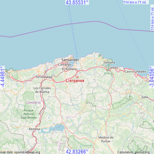
Liérganes GPS coordinates[2]
43° 20' 46.104" North, 3° 44' 48.048" West
| Map corner | latitude | longitude |
|---|---|---|
| Upper-left | 43.85531°, | -4.44981° |
| Center: | 43.34614°, | -3.74668° |
| Lower-right: | 42.83266°, | -3.04356° |
| Map W x H: | 113.7×113.7 km | = 70.6×70.6mi |
| max Lat: | 43.74134° ⇑1.8% North |
| Liérganes: | 43.34614° |
| min Lat: | ⇓98.2% South 27.64134° |
| min Long | Liérganes | max Long |
| -18.00367° | -3.74668° | 4.2899° |
| W 44%⇐ | ⇒56% E |
Elevation
Elevation of Liérganes is 95 m = 312 ft, and this is 503 m = 1650 ft below average elevation for this country.
| Max E: |
1682 m = 5518 ft | 88% |
| Avg. | 598 m = 1962 ft | |
| Liérganes | 95 m = 312 ft | |
Min E: |
0 m = 0 ft | 12% |
See also: Spain elevation on elevation.city.
Geographical zone
Liérganes is located in North temperate zone (between Tropic of Cancer and the Arctic Circle). Distance of this Northern Tropic circle is 2213.7 km =1375.5 mi to South.| Distance of | km | miles | from Liérganes |
|---|---|---|---|
| North Pole | 5187.4 | 3223.3 | to North |
| Arctic Circle | 2581.5 | 1604.1 | to North |
| Tropic Cancer | 2213.7 | 1375.5 | to South |
| Equator | 4819.6 | 2994.8 | to South |


Nearby cities:
15 places around Liérganes: (largest is in red/bold)
• Arredondo
14.4 km =8.9 mi,  124°
124°
• Camargo
13.1 km =8.1 mi,  301°
301°
• El Astillero
8.5 km =5.3 mi,  315°
315°
• Entrambasaguas
6.4 km =4 mi,  56°
56°
• Hazas de Cesto
13.9 km =8.6 mi,  66°
66°
• Penagos
5.5 km =3.4 mi,  277°
277°
• Santa Cruz de Bezana
16.7 km =10.4 mi,  310°
310°
• Santa María de Cayón
8.4 km =5.2 mi,  240°
240°
• Santander
14 km =8.7 mi,  340°
340°
• Saro
12.4 km =7.7 mi,  218°
218°
• Selaya
15.5 km =9.6 mi,  197°
197°
• Solórzano
13.5 km =8.4 mi, 72°
• Villacarriedo
14.1 km =8.8 mi, 201°
• Villafufre
14.9 km =9.3 mi,  233°
233°
• Villanueva de Villaescusa
9.7 km =6 mi, 284°
Sources, notices
• [Note1] Compared only with cities in Spain existing in our database
• [Src1] Map data: © OpenStreetMap contributors (CC-BY-SA)
• [Src2] Other city data from geonames.org with taken over terms of usage.
• [Src3] Geographical zone / Annual Mean Temperature by Robert A. Rohde @ Wikipedia
