Vilamaniscle geodata
Vilamaniscle (Catalonia) is a seat of a third-order administrative division; located in Spain in Europe/Madrid (GMT+2) time zone. With population of 170 people, there are 5264 cities with bigger population in this country. Compared to other cities in Spain, 84% of cities are located further ↓South; 99.2% of cities are located further ←West and 84% of cities have higher elevation than Vilamaniscle. Note1


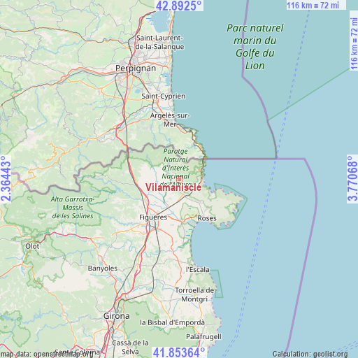
Vilamaniscle GPS coordinates[2]
42° 22' 30.792" North, 3° 4' 3.18" East
| Map corner | latitude | longitude |
|---|---|---|
| Upper-left | 42.8925°, | 2.36443° |
| Center: | 42.37522°, | 3.06755° |
| Lower-right: | 41.85364°, | 3.77068° |
| Map W x H: | 115.5×115.5 km | = 71.8×71.8mi |
| max Lat: | 43.74134° ⇑16% North |
| Vilamaniscle: | 42.37522° |
| min Lat: | ⇓84% South 27.64134° |
| min Long | Vilamaniscle | max Long |
| -18.00367° | 3.06755° | 4.2899° |
| W 99.2%⇐ | ⇒0.8% E |
Elevation
Elevation of Vilamaniscle is 156 m = 512 ft, and this is 442 m = 1450 ft below average elevation for this country.
| Max E: |
1682 m = 5518 ft | 84% |
| Avg. | 598 m = 1962 ft | |
| Vilamaniscle | 156 m = 512 ft | |
Min E: |
0 m = 0 ft | 16% |
See also: Spain elevation on elevation.city.
Geographical zone
Vilamaniscle is located in North temperate zone (between Tropic of Cancer and the Arctic Circle). Distance of this Northern Tropic circle is 2105.8 km =1308.5 mi to South.| Distance of | km | miles | from Vilamaniscle |
|---|---|---|---|
| North Pole | 5295.4 | 3290.4 | to North |
| Arctic Circle | 2689.5 | 1671.2 | to North |
| Tropic Cancer | 2105.8 | 1308.5 | to South |
| Equator | 4711.7 | 2927.7 | to South |


Nearby cities:
15 places around Vilamaniscle: (largest is in red/bold)
• Cabanes
10.5 km =6.5 mi,  224°
224°
• Capmany
12.1 km =7.5 mi,  269°
269°
• Colera
7.6 km =4.7 mi,  65°
65°
• Espolla
5.8 km =3.6 mi,  287°
287°
• Garriguella
3.5 km =2.2 mi,  183°
183°
• Llançà
7.1 km =4.4 mi,  101°
101°
• Masarac
8.2 km =5.1 mi,  250°
250°
• Mollet de Peralada
5.8 km =3.6 mi, 252°
• Pau
7.7 km =4.8 mi,  148°
148°
• Peralada
8.9 km =5.5 mi,  212°
212°
• Portbou
9.4 km =5.8 mi,  52°
52°
• Rabós
3.3 km =2.1 mi,  277°
277°
• Vilabertran
12.5 km =7.8 mi, 214°
• Vilajuïga
5.9 km =3.7 mi,  159°
159°
• el Port de la Selva
12.1 km =7.5 mi,  110°
110°
Sources, notices
• [Note1] Compared only with cities in Spain existing in our database
• [Src1] Map data: © OpenStreetMap contributors (CC-BY-SA)
• [Src2] Other city data from geonames.org with taken over terms of usage.
• [Src3] Geographical zone / Annual Mean Temperature by Robert A. Rohde @ Wikipedia
