Garriguella geodata
Garriguella (Catalonia) is a seat of a third-order administrative division; located in Spain in Europe/Madrid (GMT+2) time zone. With population of 727 people, there are 3353 cities with bigger population in this country. Compared to other cities in Spain, 83.2% of cities are located further ↓South; 99.1% of cities are located further ←West and 90.2% of cities have higher elevation than Garriguella. Note1


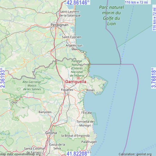
Garriguella GPS coordinates[2]
42° 20' 38.112" North, 3° 3' 54.216" East
| Map corner | latitude | longitude |
|---|---|---|
| Upper-left | 42.86146°, | 2.36193° |
| Center: | 42.34392°, | 3.06506° |
| Lower-right: | 41.82208°, | 3.76818° |
| Map W x H: | 115.6×115.6 km | = 71.8×71.8mi |
| max Lat: | 43.74134° ⇑16.8% North |
| Garriguella: | 42.34392° |
| min Lat: | ⇓83.2% South 27.64134° |
| min Long | Garriguella | max Long |
| -18.00367° | 3.06506° | 4.2899° |
| W 99.1%⇐ | ⇒0.90000000000001% E |
Elevation
Elevation of Garriguella is 63 m = 207 ft, and this is 535 m = 1755 ft below average elevation for this country.
| Max E: |
1682 m = 5518 ft | 90.2% |
| Avg. | 598 m = 1962 ft | |
| Garriguella | 63 m = 207 ft | |
Min E: |
0 m = 0 ft | 9.8% |
See also: Spain elevation on elevation.city.
Geographical zone
Garriguella is located in North temperate zone (between Tropic of Cancer and the Arctic Circle). Distance of this Northern Tropic circle is 2102.3 km =1306.3 mi to South.| Distance of | km | miles | from Garriguella |
|---|---|---|---|
| North Pole | 5298.9 | 3292.6 | to North |
| Arctic Circle | 2693 | 1673.4 | to North |
| Tropic Cancer | 2102.3 | 1306.3 | to South |
| Equator | 4708.2 | 2925.5 | to South |


Nearby cities:
15 places around Garriguella: (largest is in red/bold)
• Cabanes
8.2 km =5.1 mi,  240°
240°
• Castelló d'Empúries
9.7 km =6 mi,  175°
175°
• Colera
9.7 km =6 mi,  46°
46°
• Espolla
7.5 km =4.7 mi,  314°
314°
• Fortià
11.4 km =7.1 mi,  190°
190°
• Llançà
7.4 km =4.6 mi,  73°
73°
• Masarac
7.6 km =4.7 mi,  275°
275°
• Mollet de Peralada
5.6 km =3.5 mi,  288°
288°
• Pau
5.2 km =3.2 mi,  126°
126°
• Peralada
6.1 km =3.8 mi,  229°
229°
• Rabós
4.9 km =3 mi,  322°
322°
• Vila-sacra
9.5 km =5.9 mi,  203°
203°
• Vilabertran
9.7 km =6 mi, 225°
• Vilajuïga
3.1 km =1.9 mi, 131°
• Vilamaniscle
3.5 km =2.2 mi,  3°
3°
Sources, notices
• [Note1] Compared only with cities in Spain existing in our database
• [Src1] Map data: © OpenStreetMap contributors (CC-BY-SA)
• [Src2] Other city data from geonames.org with taken over terms of usage.
• [Src3] Geographical zone / Annual Mean Temperature by Robert A. Rohde @ Wikipedia
