Vilajuïga geodata
Vilajuïga (Catalonia) is a seat of a third-order administrative division; located in Spain in Europe/Madrid (GMT+2) time zone. With population of 1,057 people, there are 2871 cities with bigger population in this country. Compared to other cities in Spain, 82.5% of cities are located further ↓South; 99.3% of cities are located further ←West and 93.9% of cities have higher elevation than Vilajuïga. Note1


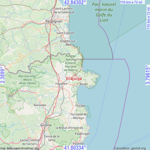
Vilajuïga GPS coordinates[2]
42° 19' 31.188" North, 3° 5' 34.872" East
| Map corner | latitude | longitude |
|---|---|---|
| Upper-left | 42.84302°, | 2.3899° |
| Center: | 42.32533°, | 3.09302° |
| Lower-right: | 41.80334°, | 3.79615° |
| Map W x H: | 115.6×115.6 km | = 71.8×71.8mi |
| max Lat: | 43.74134° ⇑17.5% North |
| Vilajuïga: | 42.32533° |
| min Lat: | ⇓82.5% South 27.64134° |
| min Long | Vilajuïga | max Long |
| -18.00367° | 3.09302° | 4.2899° |
| W 99.3%⇐ | ⇒0.7% E |
Elevation
Elevation of Vilajuïga is 32 m = 105 ft, and this is 566 m = 1857 ft below average elevation for this country.
| Max E: |
1682 m = 5518 ft | 93.9% |
| Avg. | 598 m = 1962 ft | |
| Vilajuïga | 32 m = 105 ft | |
Min E: |
0 m = 0 ft | 6.1% |
See also: Spain elevation on elevation.city.
Geographical zone
Vilajuïga is located in North temperate zone (between Tropic of Cancer and the Arctic Circle). Distance of this Northern Tropic circle is 2100.2 km =1305 mi to South.| Distance of | km | miles | from Vilajuïga |
|---|---|---|---|
| North Pole | 5300.9 | 3293.8 | to North |
| Arctic Circle | 2695 | 1674.6 | to North |
| Tropic Cancer | 2100.2 | 1305 | to South |
| Equator | 4706.1 | 2924.2 | to South |


Nearby cities:
15 places around Vilajuïga: (largest is in red/bold)
• Cabanes
9.7 km =6 mi,  258°
258°
• Castelló d'Empúries
7.8 km =4.8 mi,  191°
191°
• Colera
10 km =6.2 mi,  28°
28°
• Empuriabrava
9 km =5.6 mi,  165°
165°
• Fortià
10.2 km =6.3 mi,  206°
206°
• Garriguella
3.1 km =1.9 mi,  311°
311°
• Llançà
6.4 km =4 mi,  49°
49°
• Mollet de Peralada
8.5 km =5.3 mi,  296°
296°
• Pau
2.2 km =1.4 mi,  118°
118°
• Peralada
7.2 km =4.5 mi,  254°
254°
• Rabós
8 km =5 mi,  318°
318°
• Roses
9.9 km =6.2 mi,  135°
135°
• Vila-sacra
9 km =5.6 mi,  222°
222°
• Vilamaniscle
5.9 km =3.7 mi,  339°
339°
• el Port de la Selva
9.3 km =5.8 mi,  82°
82°
Sources, notices
• [Note1] Compared only with cities in Spain existing in our database
• [Src1] Map data: © OpenStreetMap contributors (CC-BY-SA)
• [Src2] Other city data from geonames.org with taken over terms of usage.
• [Src3] Geographical zone / Annual Mean Temperature by Robert A. Rohde @ Wikipedia
