Velayos geodata
Velayos (Castille and León) is a seat of a third-order administrative division; located in Spain in Europe/Madrid (GMT+2) time zone. With population of 276 people, there are 4601 cities with bigger population in this country. Compared to other cities in Spain, 55.2% of cities are located further ↑North; 67.6% of cities are located further →East and 83.7% of cities have lower elevation than Velayos. Note1


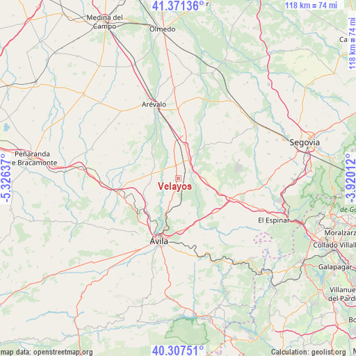
Velayos GPS coordinates[2]
40° 50' 29.652" North, 4° 37' 23.664" West
| Map corner | latitude | longitude |
|---|---|---|
| Upper-left | 41.37136°, | -5.32637° |
| Center: | 40.84157°, | -4.62324° |
| Lower-right: | 40.30751°, | -3.92012° |
| Map W x H: | 118.3×118.3 km | = 73.5×73.5mi |
| max Lat: | 43.74134° ⇑55.2% North |
| Velayos: | 40.84157° |
| min Lat: | ⇓44.8% South 27.64134° |
| min Long | Velayos | max Long |
| -18.00367° | -4.62324° | 4.2899° |
| W 32.4%⇐ | ⇒67.6% E |
Elevation
Elevation of Velayos is 936 m = 3071 ft, and this is 338 m = 1109 ft above average elevation for this country.
| Max E: |
1682 m = 5518 ft | 16.3% |
| Velayos | 936 m 3071 ft | |
| Avg. | 598 m = 1962 ft | |
Min E: |
0 m = 0 ft | 83.7% |
See also: Spain elevation on elevation.city.
Geographical zone
Velayos is located in North temperate zone (between Tropic of Cancer and the Arctic Circle). Distance of this Northern Tropic circle is 1935.2 km =1202.5 mi to South.| Distance of | km | miles | from Velayos |
|---|---|---|---|
| North Pole | 5465.9 | 3396.4 | to North |
| Arctic Circle | 2860 | 1777.1 | to North |
| Tropic Cancer | 1935.2 | 1202.5 | to South |
| Equator | 4541.2 | 2821.8 | to South |


Nearby cities:
15 places around Velayos: (largest is in red/bold)
• Adanero
11.6 km =7.2 mi,  7°
7°
• Blascosancho
4.2 km =2.6 mi,  343°
343°
• Gotarrendura
10 km =6.2 mi,  260°
260°
• Hernansancho
9.2 km =5.7 mi,  281°
281°
• Labajos
8.7 km =5.4 mi,  88°
88°
• Maello
10 km =6.2 mi,  110°
110°
• Mingorría
10.6 km =6.6 mi,  199°
199°
• Pajares de Adaja
9.3 km =5.8 mi,  351°
351°
• Pozanco
5.9 km =3.7 mi,  219°
219°
• San Esteban de los Patos
10.5 km =6.5 mi,  180°
180°
• Sanchidrián
6.8 km =4.2 mi,  31°
31°
• Santo Domingo de las Posadas
3.4 km =2.1 mi, 195°
• Tolbaños
10.6 km =6.6 mi,  160°
160°
• Vega de Santa María
1.8 km =1.1 mi,  250°
250°
• Villanueva de Gómez
9.1 km =5.7 mi,  300°
300°
Sources, notices
• [Note1] Compared only with cities in Spain existing in our database
• [Src1] Map data: © OpenStreetMap contributors (CC-BY-SA)
• [Src2] Other city data from geonames.org with taken over terms of usage.
• [Src3] Geographical zone / Annual Mean Temperature by Robert A. Rohde @ Wikipedia
