Labajos geodata
Labajos (Castille and León) is a seat of a third-order administrative division; located in Spain in Europe/Madrid (GMT+2) time zone. With population of 148 people, there are 5444 cities with bigger population in this country. Compared to other cities in Spain, 55.1% of cities are located further ↑North; 66.4% of cities are located further →East and 91.9% of cities have lower elevation than Labajos. Note1
Administrative division(s):
- Level 1: Castille and León
- Level 2: Provincia de Segovia
- Level 3: Labajos


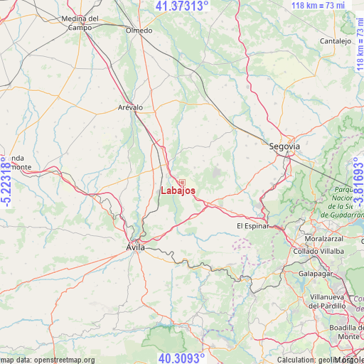
Labajos GPS coordinates[2]
40° 50' 36.06" North, 4° 31' 12.18" West
| Map corner | latitude | longitude |
|---|---|---|
| Upper-left | 41.37313°, | -5.22318° |
| Center: | 40.84335°, | -4.52005° |
| Lower-right: | 40.3093°, | -3.81693° |
| Map W x H: | 118.3×118.3 km | = 73.5×73.5mi |
| max Lat: | 43.74134° ⇑55.1% North |
| Labajos: | 40.84335° |
| min Lat: | ⇓44.9% South 27.64134° |
| min Long | Labajos | max Long |
| -18.00367° | -4.52005° | 4.2899° |
| W 33.6%⇐ | ⇒66.4% E |
Elevation
Elevation of Labajos is 1067 m = 3501 ft, and this is 469 m = 1539 ft above average elevation for this country.
| Max E: |
1682 m = 5518 ft | 8.1% |
| Labajos | 1067 m 3501 ft | |
| Avg. | 598 m = 1962 ft | |
Min E: |
0 m = 0 ft | 91.9% |
See also: Spain elevation on elevation.city.
Geographical zone
Labajos is located in North temperate zone (between Tropic of Cancer and the Arctic Circle). Distance of this Northern Tropic circle is 1935.4 km =1202.6 mi to South.| Distance of | km | miles | from Labajos |
|---|---|---|---|
| North Pole | 5465.7 | 3396.2 | to North |
| Arctic Circle | 2859.8 | 1777 | to North |
| Tropic Cancer | 1935.4 | 1202.6 | to South |
| Equator | 4541.4 | 2821.9 | to South |


Nearby cities:
15 places around Labajos: (largest is in red/bold)
• Adanero
13.4 km =8.3 mi,  327°
327°
• Bercial
10 km =6.2 mi,  44°
44°
• Blascosancho
10.6 km =6.6 mi,  291°
291°
• Ituero y Lama
12.8 km =8 mi,  111°
111°
• Maello
3.8 km =2.4 mi,  169°
169°
• Marugán
13 km =8.1 mi,  61°
61°
• Muñopedro
6.4 km =4 mi, 39°
• Pajares de Adaja
13.5 km =8.4 mi,  311°
311°
• Pozanco
13.3 km =8.3 mi,  249°
249°
• Sanchidrián
7.6 km =4.7 mi,  317°
317°
• Santo Domingo de las Posadas
10.2 km =6.3 mi, 249°
• Tolbaños
11.4 km =7.1 mi,  207°
207°
• Vega de Santa María
10.4 km =6.5 mi,  265°
265°
• Velayos
8.7 km =5.4 mi, 268°
• Villacastín
11.4 km =7.1 mi,  128°
128°
Sources, notices
• [Note1] Compared only with cities in Spain existing in our database
• [Src1] Map data: © OpenStreetMap contributors (CC-BY-SA)
• [Src2] Other city data from geonames.org with taken over terms of usage.
• [Src3] Geographical zone / Annual Mean Temperature by Robert A. Rohde @ Wikipedia
