Maello geodata
Maello (Castille and León) is a seat of a third-order administrative division; located in Spain in Europe/Madrid (GMT+2) time zone. With population of 684 people, there are 3431 cities with bigger population in this country. Compared to other cities in Spain, 56% of cities are located further ↑North; 66.3% of cities are located further →East and 90% of cities have lower elevation than Maello. Note1


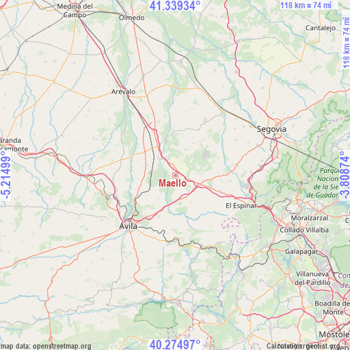
Maello GPS coordinates[2]
40° 48' 33.444" North, 4° 30' 42.696" West
| Map corner | latitude | longitude |
|---|---|---|
| Upper-left | 41.33934°, | -5.21499° |
| Center: | 40.80929°, | -4.51186° |
| Lower-right: | 40.27497°, | -3.80874° |
| Map W x H: | 118.3×118.3 km | = 73.5×73.5mi |
| max Lat: | 43.74134° ⇑56% North |
| Maello: | 40.80929° |
| min Lat: | ⇓44% South 27.64134° |
| min Long | Maello | max Long |
| -18.00367° | -4.51186° | 4.2899° |
| W 33.7%⇐ | ⇒66.3% E |
Elevation
Elevation of Maello is 1032 m = 3386 ft, and this is 434 m = 1424 ft above average elevation for this country.
| Max E: |
1682 m = 5518 ft | 10% |
| Maello | 1032 m 3386 ft | |
| Avg. | 598 m = 1962 ft | |
Min E: |
0 m = 0 ft | 90% |
See also: Spain elevation on elevation.city.
Geographical zone
Maello is located in North temperate zone (between Tropic of Cancer and the Arctic Circle). Distance of this Northern Tropic circle is 1931.6 km =1200.2 mi to South.| Distance of | km | miles | from Maello |
|---|---|---|---|
| North Pole | 5469.5 | 3398.6 | to North |
| Arctic Circle | 2863.6 | 1779.4 | to North |
| Tropic Cancer | 1931.6 | 1200.2 | to South |
| Equator | 4537.6 | 2819.5 | to South |


Nearby cities:
15 places around Maello: (largest is in red/bold)
• Bercial
12.6 km =7.8 mi,  30°
30°
• Blascosancho
13 km =8.1 mi,  305°
305°
• Ituero y Lama
11.2 km =7 mi,  94°
94°
• Labajos
3.8 km =2.4 mi,  349°
349°
• Mediana de Voltoya
12.8 km =8 mi,  199°
199°
• Muñopedro
9.4 km =5.8 mi,  20°
20°
• Ojos-Albos
11.5 km =7.1 mi,  181°
181°
• Pozanco
13.2 km =8.2 mi,  265°
265°
• San Esteban de los Patos
11.7 km =7.3 mi,  233°
233°
• Sanchidrián
11 km =6.8 mi,  328°
328°
• Santo Domingo de las Posadas
10.3 km =6.4 mi, 271°
• Tolbaños
8.7 km =5.4 mi,  222°
222°
• Vega de Santa María
11.4 km =7.1 mi,  285°
285°
• Velayos
10 km =6.2 mi, 290°
• Villacastín
8.9 km =5.5 mi,  111°
111°
Sources, notices
• [Note1] Compared only with cities in Spain existing in our database
• [Src1] Map data: © OpenStreetMap contributors (CC-BY-SA)
• [Src2] Other city data from geonames.org with taken over terms of usage.
• [Src3] Geographical zone / Annual Mean Temperature by Robert A. Rohde @ Wikipedia
