Libros geodata
Libros (Aragon) is a seat of a third-order administrative division; located in Spain in Europe/Madrid (GMT+2) time zone. With population of 147 people, there are 5452 cities with bigger population in this country. Compared to other cities in Spain, 67.8% of cities are located further ↑North; 75.4% of cities are located further ←West and 64.1% of cities have lower elevation than Libros. Note1


Libros GPS coordinates[2]
40° 9' 47.196" North, 1° 14' 0.996" West
| Map corner | latitude | longitude |
|---|---|---|
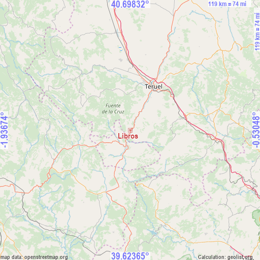
| Upper-left | 40.69832°, | -1.93674° |
| Center: | 40.16311°, | -1.23361° |
| Lower-right: | 39.62365°, | -0.53048° |
| Map W x H: | 119.5×119.5 km | = 74.3×74.3mi |
| max Lat: | 43.74134° ⇑67.8% North |
| Libros: | 40.16311° |
| min Lat: | ⇓32.2% South 27.64134° |
| min Long | Libros | max Long |
| -18.00367° | -1.23361° | 4.2899° |
| W 75.4%⇐ | ⇒24.6% E |
Elevation
Elevation of Libros is 772 m = 2533 ft, and this is 174 m = 571 ft above average elevation for this country.
| Max E: |
1682 m = 5518 ft | 35.9% |
| Libros | 772 m 2533 ft | |
| Avg. | 598 m = 1962 ft | |
Min E: |
0 m = 0 ft | 64.1% |
See also: Spain elevation on elevation.city.
Geographical zone
Libros is located in North temperate zone (between Tropic of Cancer and the Arctic Circle). Distance of this Northern Tropic circle is 1859.8 km =1155.6 mi to South.| Distance of | km | miles | from Libros |
|---|---|---|---|
| North Pole | 5541.3 | 3443.2 | to North |
| Arctic Circle | 2935.5 | 1824 | to North |
| Tropic Cancer | 1859.8 | 1155.6 | to South |
| Equator | 4465.7 | 2774.9 | to South |


Nearby cities:
15 places around Libros: (largest is in red/bold)
• Ademuz
12.2 km =7.6 mi,  201°
201°
• Alobras
13.2 km =8.2 mi,  278°
278°
• Casas Altas
14.7 km =9.1 mi,  191°
191°
• Cascante del Río
10.8 km =6.7 mi,  69°
69°
• Castielfabib
7 km =4.3 mi,  238°
238°
• Cubla
14.1 km =8.8 mi, 68°
• Riodeva
8.8 km =5.5 mi,  126°
126°
• Rubiales
13 km =8.1 mi,  345°
345°
• Tormón
11.1 km =6.9 mi,  293°
293°
• Tramacastiel
2.9 km =1.8 mi, 347°
• Valacloche
12.5 km =7.8 mi,  75°
75°
• Vallanca
13.7 km =8.5 mi,  218°
218°
• Veguillas de la Sierra
14.2 km =8.8 mi,  264°
264°
• Villastar
14.9 km =9.3 mi,  28°
28°
• Villel
8.9 km =5.5 mi, 26°
Sources, notices
• [Note1] Compared only with cities in Spain existing in our database
• [Src1] Map data: © OpenStreetMap contributors (CC-BY-SA)
• [Src2] Other city data from geonames.org with taken over terms of usage.
• [Src3] Geographical zone / Annual Mean Temperature by Robert A. Rohde @ Wikipedia
