Castielfabib geodata
Castielfabib (Valencia) is a seat of a third-order administrative division; located in Spain in Europe/Madrid (GMT+2) time zone. With population of 284 people, there are 4572 cities with bigger population in this country. Compared to other cities in Spain, 68.2% of cities are located further ↑North; 74.7% of cities are located further ←West and 83.3% of cities have lower elevation than Castielfabib. Note1


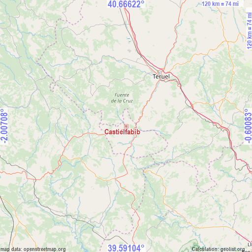
Castielfabib GPS coordinates[2]
40° 7' 50.736" North, 1° 18' 14.256" West
| Map corner | latitude | longitude |
|---|---|---|
| Upper-left | 40.66622°, | -2.00708° |
| Center: | 40.13076°, | -1.30396° |
| Lower-right: | 39.59104°, | -0.60083° |
| Map W x H: | 119.5×119.5 km | = 74.3×74.3mi |
| max Lat: | 43.74134° ⇑68.2% North |
| Castielfabib: | 40.13076° |
| min Lat: | ⇓31.8% South 27.64134° |
| min Long | Castielfabib | max Long |
| -18.00367° | -1.30396° | 4.2899° |
| W 74.7%⇐ | ⇒25.3% E |
Elevation
Elevation of Castielfabib is 931 m = 3054 ft, and this is 333 m = 1093 ft above average elevation for this country.
| Max E: |
1682 m = 5518 ft | 16.7% |
| Castielfabib | 931 m 3054 ft | |
| Avg. | 598 m = 1962 ft | |
Min E: |
0 m = 0 ft | 83.3% |
See also: Spain elevation on elevation.city.
Geographical zone
Castielfabib is located in North temperate zone (between Tropic of Cancer and the Arctic Circle). Distance of this Northern Tropic circle is 1856.2 km =1153.4 mi to South.| Distance of | km | miles | from Castielfabib |
|---|---|---|---|
| North Pole | 5544.9 | 3445.4 | to North |
| Arctic Circle | 2939.1 | 1826.3 | to North |
| Tropic Cancer | 1856.2 | 1153.4 | to South |
| Equator | 4462.1 | 2772.6 | to South |


Nearby cities:
15 places around Castielfabib: (largest is in red/bold)
• Ademuz
7.9 km =4.9 mi,  169°
169°
• Alobras
9.1 km =5.7 mi,  308°
308°
• Casas Altas
11.3 km =7 mi,  163°
163°
• Casas Bajas
13.1 km =8.1 mi, 165°
• Jabaloyas
15.1 km =9.4 mi,  323°
323°
• Libros
7 km =4.3 mi,  58°
58°
• Puebla de San Miguel
17.1 km =10.6 mi,  121°
121°
• Riodeva
13.2 km =8.2 mi,  96°
96°
• Rubiales
16.4 km =10.2 mi,  9°
9°
• Salvacañete
17 km =10.6 mi,  258°
258°
• Tormón
9.1 km =5.7 mi,  331°
331°
• Tramacastiel
8.4 km =5.2 mi,  39°
39°
• Vallanca
7.6 km =4.7 mi,  199°
199°
• Veguillas de la Sierra
8.4 km =5.2 mi,  284°
284°
• Villel
15.3 km =9.5 mi, 40°
Sources, notices
• [Note1] Compared only with cities in Spain existing in our database
• [Src1] Map data: © OpenStreetMap contributors (CC-BY-SA)
• [Src2] Other city data from geonames.org with taken over terms of usage.
• [Src3] Geographical zone / Annual Mean Temperature by Robert A. Rohde @ Wikipedia
