Lupiana geodata
Lupiana (Castille-La Mancha) is a seat of a third-order administrative division; located in Spain in Europe/Madrid (GMT+2) time zone. With population of 221 people, there are 4905 cities with bigger population in this country. Compared to other cities in Spain, 59.6% of cities are located further ↑North; 53.6% of cities are located further ←West and 62.4% of cities have lower elevation than Lupiana. Note1
Administrative division(s):
- Level 1: Castille-La Mancha
- Level 2: Provincia de Guadalajara
- Level 3: Lupiana


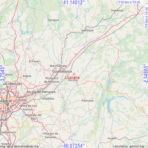
Lupiana GPS coordinates[2]
40° 36' 30.456" North, 3° 3' 4.248" West
| Map corner | latitude | longitude |
|---|---|---|
| Upper-left | 41.14012°, | -3.7543° |
| Center: | 40.60846°, | -3.05118° |
| Lower-right: | 40.07254°, | -2.34805° |
| Map W x H: | 118.7×118.7 km | = 73.8×73.8mi |
| max Lat: | 43.74134° ⇑59.6% North |
| Lupiana: | 40.60846° |
| min Lat: | ⇓40.4% South 27.64134° |
| min Long | Lupiana | max Long |
| -18.00367° | -3.05118° | 4.2899° |
| W 53.6%⇐ | ⇒46.4% E |
Elevation
Elevation of Lupiana is 760 m = 2493 ft, and this is 162 m = 531 ft above average elevation for this country.
| Max E: |
1682 m = 5518 ft | 37.6% |
| Lupiana | 760 m 2493 ft | |
| Avg. | 598 m = 1962 ft | |
Min E: |
0 m = 0 ft | 62.4% |
See also: Spain elevation on elevation.city.
Geographical zone
Lupiana is located in North temperate zone (between Tropic of Cancer and the Arctic Circle). Distance of this Northern Tropic circle is 1909.3 km =1186.4 mi to South.| Distance of | km | miles | from Lupiana |
|---|---|---|---|
| North Pole | 5491.8 | 3412.4 | to North |
| Arctic Circle | 2885.9 | 1793.2 | to North |
| Tropic Cancer | 1909.3 | 1186.4 | to South |
| Equator | 4515.2 | 2805.6 | to South |


Nearby cities:
15 places around Lupiana: (largest is in red/bold)
• Aldeanueva de Guadalajara
8 km =5 mi,  4°
4°
• Armuña de Tajuña
9.1 km =5.7 mi,  167°
167°
• Atanzón
8 km =5 mi,  35°
35°
• Caspueñas
11.4 km =7.1 mi,  32°
32°
• Centenera
4.7 km =2.9 mi,  359°
359°
• Chiloeches
10.1 km =6.3 mi,  245°
245°
• Fuentelviejo
10.7 km =6.6 mi,  148°
148°
• Guadalajara
9.6 km =6 mi,  283°
283°
• Horche
5 km =3.1 mi,  189°
189°
• Romanones
6.6 km =4.1 mi,  128°
128°
• Tendilla
10.7 km =6.6 mi, 132°
• Valdeavellano
9.4 km =5.8 mi,  47°
47°
• Valdegrudas
11.9 km =7.4 mi,  16°
16°
• Valfermoso de Tajuña
8.3 km =5.2 mi,  81°
81°
• Yebes
9.8 km =6.1 mi,  209°
209°
Sources, notices
• [Note1] Compared only with cities in Spain existing in our database
• [Src1] Map data: © OpenStreetMap contributors (CC-BY-SA)
• [Src2] Other city data from geonames.org with taken over terms of usage.
• [Src3] Geographical zone / Annual Mean Temperature by Robert A. Rohde @ Wikipedia
