Valdecuenca geodata
Valdecuenca (Aragon) is a seat of a third-order administrative division; located in Spain in Europe/Madrid (GMT+2) time zone. With population of 48 people, there are 6485 cities with bigger population in this country. Compared to other cities in Spain, 65.8% of cities are located further ↑North; 73.8% of cities are located further ←West and 98.9% of cities have lower elevation than Valdecuenca. Note1


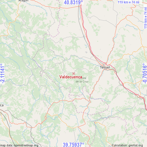
Valdecuenca GPS coordinates[2]
40° 17' 51.936" North, 1° 24' 29.844" West
| Map corner | latitude | longitude |
|---|---|---|
| Upper-left | 40.8319°, | -2.11141° |
| Center: | 40.29776°, | -1.40829° |
| Lower-right: | 39.75937°, | -0.70516° |
| Map W x H: | 119.3×119.3 km | = 74.1×74.1mi |
| max Lat: | 43.74134° ⇑65.8% North |
| Valdecuenca: | 40.29776° |
| min Lat: | ⇓34.2% South 27.64134° |
| min Long | Valdecuenca | max Long |
| -18.00367° | -1.40829° | 4.2899° |
| W 73.8%⇐ | ⇒26.2% E |
Elevation
Elevation of Valdecuenca is 1337 m = 4386 ft, and this is 739 m = 2425 ft above average elevation for this country.
| Max E: |
1682 m = 5518 ft | 1.1% |
| Valdecuenca | 1337 m 4386 ft | |
| Avg. | 598 m = 1962 ft | |
Min E: |
0 m = 0 ft | 98.9% |
See also: Spain elevation on elevation.city.
Geographical zone
Valdecuenca is located in North temperate zone (between Tropic of Cancer and the Arctic Circle). Distance of this Northern Tropic circle is 1874.8 km =1164.9 mi to South.| Distance of | km | miles | from Valdecuenca |
|---|---|---|---|
| North Pole | 5526.4 | 3433.9 | to North |
| Arctic Circle | 2920.5 | 1814.7 | to North |
| Tropic Cancer | 1874.8 | 1164.9 | to South |
| Equator | 4480.7 | 2784.2 | to South |


Nearby cities:
15 places around Valdecuenca: (largest is in red/bold)
• Albarracín
12.6 km =7.8 mi,  346°
346°
• Alobras
13 km =8.1 mi,  172°
172°
• Bezas
7.9 km =4.9 mi,  62°
62°
• Calomarde
16.4 km =10.2 mi,  300°
300°
• Frías de Albarracín
18 km =11.2 mi,  284°
284°
• Gea de Albarracín
13.6 km =8.5 mi,  21°
21°
• Jabaloyas
6.4 km =4 mi,  180°
180°
• Moscardón
11.6 km =7.2 mi,  289°
289°
• Royuela
12.6 km =7.8 mi,  315°
315°
• Rubiales
11.8 km =7.3 mi,  101°
101°
• Saldón
3.5 km =2.2 mi,  331°
331°
• Terriente
8.1 km =5 mi,  269°
269°
• Tormón
11.5 km =7.1 mi,  156°
156°
• Torres de Albarracín
17.8 km =11.1 mi, 323°
• Veguillas de la Sierra
16.4 km =10.2 mi, 177°
Sources, notices
• [Note1] Compared only with cities in Spain existing in our database
• [Src1] Map data: © OpenStreetMap contributors (CC-BY-SA)
• [Src2] Other city data from geonames.org with taken over terms of usage.
• [Src3] Geographical zone / Annual Mean Temperature by Robert A. Rohde @ Wikipedia
