Jabaloyas geodata
Jabaloyas (Aragon) is a seat of a third-order administrative division; located in Spain in Europe/Madrid (GMT+2) time zone. With population of 81 people, there are 6123 cities with bigger population in this country. Compared to other cities in Spain, 66.5% of cities are located further ↑North; 73.8% of cities are located further ←West and 99.4% of cities have lower elevation than Jabaloyas. Note1


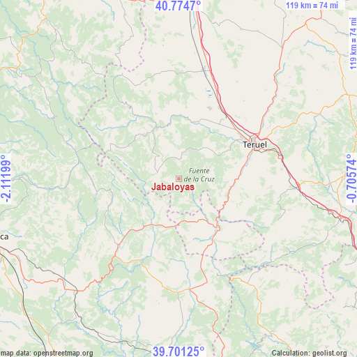
Jabaloyas GPS coordinates[2]
40° 14' 24.36" North, 1° 24' 31.896" West
| Map corner | latitude | longitude |
|---|---|---|
| Upper-left | 40.7747°, | -2.11199° |
| Center: | 40.2401°, | -1.40886° |
| Lower-right: | 39.70125°, | -0.70574° |
| Map W x H: | 119.4×119.4 km | = 74.2×74.2mi |
| max Lat: | 43.74134° ⇑66.5% North |
| Jabaloyas: | 40.2401° |
| min Lat: | ⇓33.5% South 27.64134° |
| min Long | Jabaloyas | max Long |
| -18.00367° | -1.40886° | 4.2899° |
| W 73.8%⇐ | ⇒26.2% E |
Elevation
Elevation of Jabaloyas is 1406 m = 4613 ft, and this is 808 m = 2651 ft above average elevation for this country.
| Max E: |
1682 m = 5518 ft | 0.59999999999999% |
| Jabaloyas | 1406 m 4613 ft | |
| Avg. | 598 m = 1962 ft | |
Min E: |
0 m = 0 ft | 99.4% |
See also: Spain elevation on elevation.city.
Geographical zone
Jabaloyas is located in North temperate zone (between Tropic of Cancer and the Arctic Circle). Distance of this Northern Tropic circle is 1868.4 km =1161 mi to South.| Distance of | km | miles | from Jabaloyas |
|---|---|---|---|
| North Pole | 5532.8 | 3437.9 | to North |
| Arctic Circle | 2926.9 | 1818.7 | to North |
| Tropic Cancer | 1868.4 | 1161 | to South |
| Equator | 4474.3 | 2780.2 | to South |


Nearby cities:
15 places around Jabaloyas: (largest is in red/bold)
• Alobras
6.7 km =4.2 mi,  164°
164°
• Bezas
12.3 km =7.6 mi,  35°
35°
• Castielfabib
15.1 km =9.4 mi,  143°
143°
• Libros
17.2 km =10.7 mi,  119°
119°
• Moscardón
15 km =9.3 mi,  313°
313°
• Royuela
17.8 km =11.1 mi,  330°
330°
• Rubiales
12.3 km =7.6 mi,  70°
70°
• Saldón
9.6 km =6 mi,  350°
350°
• Salvacañete
17.4 km =10.8 mi,  206°
206°
• Terriente
10.3 km =6.4 mi, 308°
• Tormón
6.2 km =3.9 mi,  131°
131°
• Tramacastiel
15.4 km =9.6 mi,  111°
111°
• Valdecuenca
6.4 km =4 mi,  0°
0°
• Veguillas de la Sierra
10 km =6.2 mi,  175°
175°
• Zafrilla
18.2 km =11.3 mi,  255°
255°
Sources, notices
• [Note1] Compared only with cities in Spain existing in our database
• [Src1] Map data: © OpenStreetMap contributors (CC-BY-SA)
• [Src2] Other city data from geonames.org with taken over terms of usage.
• [Src3] Geographical zone / Annual Mean Temperature by Robert A. Rohde @ Wikipedia
