Royuela geodata
Royuela (Aragon) is a seat of a third-order administrative division; located in Spain in Europe/Madrid (GMT+2) time zone. With population of 222 people, there are 4898 cities with bigger population in this country. Compared to other cities in Spain, 64.4% of cities are located further ↑North; 72.7% of cities are located further ←West and 97.1% of cities have lower elevation than Royuela. Note1


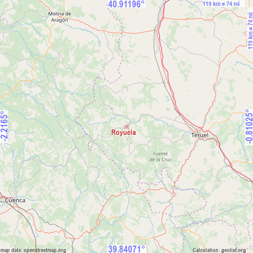
Royuela GPS coordinates[2]
40° 22' 42.456" North, 1° 30' 48.132" West
| Map corner | latitude | longitude |
|---|---|---|
| Upper-left | 40.91196°, | -2.2165° |
| Center: | 40.37846°, | -1.51337° |
| Lower-right: | 39.84071°, | -0.81025° |
| Map W x H: | 119.1×119.1 km | = 74×74mi |
| max Lat: | 43.74134° ⇑64.4% North |
| Royuela: | 40.37846° |
| min Lat: | ⇓35.6% South 27.64134° |
| min Long | Royuela | max Long |
| -18.00367° | -1.51337° | 4.2899° |
| W 72.7%⇐ | ⇒27.3% E |
Elevation
Elevation of Royuela is 1207 m = 3960 ft, and this is 609 m = 1998 ft above average elevation for this country.
| Max E: |
1682 m = 5518 ft | 2.9% |
| Royuela | 1207 m 3960 ft | |
| Avg. | 598 m = 1962 ft | |
Min E: |
0 m = 0 ft | 97.1% |
See also: Spain elevation on elevation.city.
Geographical zone
Royuela is located in North temperate zone (between Tropic of Cancer and the Arctic Circle). Distance of this Northern Tropic circle is 1883.7 km =1170.5 mi to South.| Distance of | km | miles | from Royuela |
|---|---|---|---|
| North Pole | 5517.4 | 3428.4 | to North |
| Arctic Circle | 2911.5 | 1809.1 | to North |
| Tropic Cancer | 1883.7 | 1170.5 | to South |
| Equator | 4489.7 | 2789.8 | to South |


Nearby cities:
15 places around Royuela: (largest is in red/bold)
• Albarracín
6.8 km =4.2 mi,  60°
60°
• Bezas
16.8 km =10.4 mi,  108°
108°
• Bronchales
16.1 km =10 mi,  336°
336°
• Calomarde
5.2 km =3.2 mi,  262°
262°
• Frías de Albarracín
9.7 km =6 mi,  242°
242°
• Gea de Albarracín
14.4 km =8.9 mi,  75°
75°
• Guadalaviar
17.4 km =10.8 mi,  273°
273°
• Monterde de Albarracín
13.3 km =8.3 mi,  7°
7°
• Moscardón
5.4 km =3.4 mi,  201°
201°
• Saldón
9.4 km =5.8 mi,  129°
129°
• Terriente
9 km =5.6 mi,  174°
174°
• Torres de Albarracín
5.6 km =3.5 mi, 343°
• Tramacastilla
7.8 km =4.8 mi,  318°
318°
• Valdecuenca
12.6 km =7.8 mi,  135°
135°
• Villar del Cobo
13.7 km =8.5 mi,  277°
277°
Sources, notices
• [Note1] Compared only with cities in Spain existing in our database
• [Src1] Map data: © OpenStreetMap contributors (CC-BY-SA)
• [Src2] Other city data from geonames.org with taken over terms of usage.
• [Src3] Geographical zone / Annual Mean Temperature by Robert A. Rohde @ Wikipedia
