Bezas geodata
Bezas (Aragon) is a seat of a third-order administrative division; located in Spain in Europe/Madrid (GMT+2) time zone. With population of 78 people, there are 6162 cities with bigger population in this country. Compared to other cities in Spain, 65.2% of cities are located further ↑North; 74.5% of cities are located further ←West and 95.9% of cities have lower elevation than Bezas. Note1


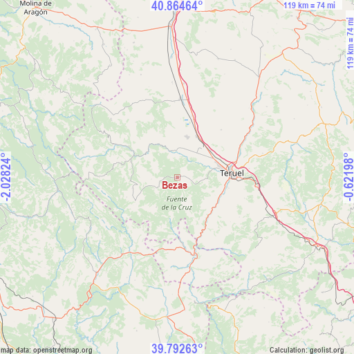
Bezas GPS coordinates[2]
40° 19' 50.736" North, 1° 19' 30.396" West
| Map corner | latitude | longitude |
|---|---|---|
| Upper-left | 40.86464°, | -2.02824° |
| Center: | 40.33076°, | -1.32511° |
| Lower-right: | 39.79263°, | -0.62198° |
| Map W x H: | 119.2×119.2 km | = 74.1×74.1mi |
| max Lat: | 43.74134° ⇑65.2% North |
| Bezas: | 40.33076° |
| min Lat: | ⇓34.8% South 27.64134° |
| min Long | Bezas | max Long |
| -18.00367° | -1.32511° | 4.2899° |
| W 74.5%⇐ | ⇒25.5% E |
Elevation
Elevation of Bezas is 1166 m = 3825 ft, and this is 568 m = 1864 ft above average elevation for this country.
| Max E: |
1682 m = 5518 ft | 4.1% |
| Bezas | 1166 m 3825 ft | |
| Avg. | 598 m = 1962 ft | |
Min E: |
0 m = 0 ft | 95.9% |
See also: Spain elevation on elevation.city.
Geographical zone
Bezas is located in North temperate zone (between Tropic of Cancer and the Arctic Circle). Distance of this Northern Tropic circle is 1878.4 km =1167.2 mi to South.| Distance of | km | miles | from Bezas |
|---|---|---|---|
| North Pole | 5522.7 | 3431.6 | to North |
| Arctic Circle | 2916.8 | 1812.4 | to North |
| Tropic Cancer | 1878.4 | 1167.2 | to South |
| Equator | 4484.4 | 2786.5 | to South |


Nearby cities:
15 places around Bezas: (largest is in red/bold)
• Albarracín
13.2 km =8.2 mi,  310°
310°
• Alobras
17.4 km =10.8 mi,  197°
197°
• Cella
14 km =8.7 mi,  13°
13°
• Gea de Albarracín
9.1 km =5.7 mi,  347°
347°
• Jabaloyas
12.3 km =7.6 mi,  215°
215°
• Moscardón
17.9 km =11.1 mi,  270°
270°
• Royuela
16.8 km =10.4 mi,  288°
288°
• Rubiales
7.6 km =4.7 mi,  143°
143°
• Saldón
8.7 km =5.4 mi, 265°
• Terriente
15.6 km =9.7 mi,  256°
256°
• Tormón
14.5 km =9 mi,  189°
189°
• Tramacastiel
17.4 km =10.8 mi,  155°
155°
• Valdecuenca
7.9 km =4.9 mi,  242°
242°
• Villastar
15.7 km =9.8 mi,  110°
110°
• Villel
15.9 km =9.9 mi,  132°
132°
Sources, notices
• [Note1] Compared only with cities in Spain existing in our database
• [Src1] Map data: © OpenStreetMap contributors (CC-BY-SA)
• [Src2] Other city data from geonames.org with taken over terms of usage.
• [Src3] Geographical zone / Annual Mean Temperature by Robert A. Rohde @ Wikipedia
