Terriente geodata
Terriente (Aragon) is a seat of a third-order administrative division; located in Spain in Europe/Madrid (GMT+2) time zone. With population of 190 people, there are 5108 cities with bigger population in this country. Compared to other cities in Spain, 65.8% of cities are located further ↑North; 72.9% of cities are located further ←West and 99.6% of cities have lower elevation than Terriente. Note1


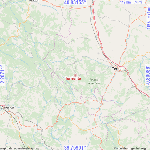
Terriente GPS coordinates[2]
40° 17' 50.676" North, 1° 30' 14.364" West
| Map corner | latitude | longitude |
|---|---|---|
| Upper-left | 40.83155°, | -2.20711° |
| Center: | 40.29741°, | -1.50399° |
| Lower-right: | 39.75901°, | -0.80086° |
| Map W x H: | 119.3×119.3 km | = 74.1×74.1mi |
| max Lat: | 43.74134° ⇑65.8% North |
| Terriente: | 40.29741° |
| min Lat: | ⇓34.2% South 27.64134° |
| min Long | Terriente | max Long |
| -18.00367° | -1.50399° | 4.2899° |
| W 72.9%⇐ | ⇒27.1% E |
Elevation
Elevation of Terriente is 1435 m = 4708 ft, and this is 837 m = 2746 ft above average elevation for this country.
| Max E: |
1682 m = 5518 ft | 0.40000000000001% |
| Terriente | 1435 m 4708 ft | |
| Avg. | 598 m = 1962 ft | |
Min E: |
0 m = 0 ft | 99.6% |
See also: Spain elevation on elevation.city.
Geographical zone
Terriente is located in North temperate zone (between Tropic of Cancer and the Arctic Circle). Distance of this Northern Tropic circle is 1874.7 km =1164.9 mi to South.| Distance of | km | miles | from Terriente |
|---|---|---|---|
| North Pole | 5526.4 | 3433.9 | to North |
| Arctic Circle | 2920.5 | 1814.7 | to North |
| Tropic Cancer | 1874.7 | 1164.9 | to South |
| Equator | 4480.7 | 2784.2 | to South |


Nearby cities:
15 places around Terriente: (largest is in red/bold)
• Albarracín
13.3 km =8.3 mi,  22°
22°
• Alobras
16.2 km =10.1 mi,  142°
142°
• Bezas
15.6 km =9.7 mi,  76°
76°
• Calomarde
10.3 km =6.4 mi,  324°
324°
• Frías de Albarracín
10.4 km =6.5 mi,  295°
295°
• Jabaloyas
10.3 km =6.4 mi,  128°
128°
• Moscardón
4.8 km =3 mi, 324°
• Royuela
9 km =5.6 mi,  354°
354°
• Saldón
7.2 km =4.5 mi,  64°
64°
• Tormón
16.5 km =10.3 mi, 129°
• Torres de Albarracín
14.6 km =9.1 mi, 350°
• Tramacastilla
16 km =9.9 mi,  337°
337°
• Valdecuenca
8.1 km =5 mi,  89°
89°
• Villar del Cobo
18 km =11.2 mi,  307°
307°
• Zafrilla
14.4 km =8.9 mi,  221°
221°
Sources, notices
• [Note1] Compared only with cities in Spain existing in our database
• [Src1] Map data: © OpenStreetMap contributors (CC-BY-SA)
• [Src2] Other city data from geonames.org with taken over terms of usage.
• [Src3] Geographical zone / Annual Mean Temperature by Robert A. Rohde @ Wikipedia
