Urnieta geodata
Urnieta (Basque Country) is a seat of a third-order administrative division; located in Spain in Europe/Madrid (GMT+2) time zone. With population of 5,827 people, there are 1157 cities with bigger population in this country. Compared to other cities in Spain, 96.9% of cities are located further ↓South; 67.6% of cities are located further ←West and 90.4% of cities have higher elevation than Urnieta. Note1


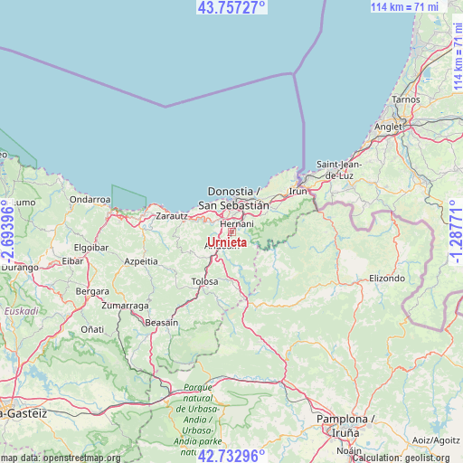
Urnieta GPS coordinates[2]
43° 14' 50.172" North, 1° 59' 27.024" West
| Map corner | latitude | longitude |
|---|---|---|
| Upper-left | 43.75727°, | -2.69396° |
| Center: | 43.24727°, | -1.99084° |
| Lower-right: | 42.73296°, | -1.28771° |
| Map W x H: | 113.9×113.9 km | = 70.8×70.8mi |
| max Lat: | 43.74134° ⇑3.1% North |
| Urnieta: | 43.24727° |
| min Lat: | ⇓96.9% South 27.64134° |
| min Long | Urnieta | max Long |
| -18.00367° | -1.99084° | 4.2899° |
| W 67.6%⇐ | ⇒32.4% E |
Elevation
Elevation of Urnieta is 60 m = 197 ft, and this is 538 m = 1765 ft below average elevation for this country.
| Max E: |
1682 m = 5518 ft | 90.4% |
| Avg. | 598 m = 1962 ft | |
| Urnieta | 60 m = 197 ft | |
Min E: |
0 m = 0 ft | 9.6% |
See also: Spain elevation on elevation.city.
Geographical zone
Urnieta is located in North temperate zone (between Tropic of Cancer and the Arctic Circle). Distance of this Northern Tropic circle is 2202.7 km =1368.7 mi to South.| Distance of | km | miles | from Urnieta |
|---|---|---|---|
| North Pole | 5198.4 | 3230.1 | to North |
| Arctic Circle | 2592.5 | 1610.9 | to North |
| Tropic Cancer | 2202.7 | 1368.7 | to South |
| Equator | 4808.6 | 2987.9 | to South |


Nearby cities:
15 places around Urnieta: (largest is in red/bold)
• Aduna
6.8 km =4.2 mi,  224°
224°
• Andoain
4.4 km =2.7 mi, 219°
• Arano
9.4 km =5.8 mi,  124°
124°
• Asteasu
10.5 km =6.5 mi,  235°
235°
• Astigarraga
5.3 km =3.3 mi,  43°
43°
• Donostia / San Sebastián
7.4 km =4.6 mi,  9°
9°
• Errenteria
10.2 km =6.3 mi, 44°
• Hernani
2.4 km =1.5 mi,  29°
29°
• Irura
10.9 km =6.8 mi,  214°
214°
• Lasarte
3.4 km =2.1 mi,  312°
312°
• Oria
2.4 km =1.5 mi,  291°
291°
• Pasaia
10.1 km =6.3 mi, 30°
• Usurbil
5.4 km =3.4 mi,  299°
299°
• Villabona
8.5 km =5.3 mi, 216°
• Zizurkil
8.6 km =5.3 mi,  231°
231°
Sources, notices
• [Note1] Compared only with cities in Spain existing in our database
• [Src1] Map data: © OpenStreetMap contributors (CC-BY-SA)
• [Src2] Other city data from geonames.org with taken over terms of usage.
• [Src3] Geographical zone / Annual Mean Temperature by Robert A. Rohde @ Wikipedia
