Donostia / San Sebastián geodata
Donostia / San Sebastián (Basque Country) is a seat of a second-order administrative division; located in Spain in Europe/Madrid (GMT+2) time zone. With population of 185,357 people, there are 40 cities with bigger population in this country. Compared to other cities in Spain, 97.8% of cities are located further ↓South; 67.8% of cities are located further ←West and 96.6% of cities have higher elevation than Donostia / San Sebastián. Note1
Administrative division(s):
- Level 1: Basque Country
- Level 2: Gipuzkoa
- Level 3: Donostia / San Sebastián
Current local time in Donostia / San Sebastián:
09:18 PM, ThursdayDifference from your time zone: hours


Donostia / San Sebastián GPS coordinates[2]
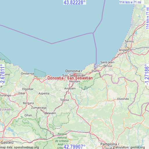
43° 18' 46.188" North, 1° 58' 29.964" West
| Map corner | latitude | longitude |
|---|---|---|
| Upper-left | 43.82228°, | -2.67811° |
| Center: | 43.31283°, | -1.97499° |
| Lower-right: | 42.79907°, | -1.27186° |
| Map W x H: | 113.8×113.8 km | = 70.7×70.7mi |
| max Lat: | 43.74134° ⇑2.2% North |
| Donostia / San Sebastián: | 43.31283° |
| min Lat: | ⇓97.8% South 27.64134° |
| min Long | Donostia / San | max Long |
| -18.00367° | -1.97499° | 4.2899° |
| W 67.8%⇐ | ⇒32.2% E |
Elevation
Elevation of Donostia / San Sebastián is 17 m = 56 ft, and this is 581 m = 1906 ft below average elevation for this country.
| Max E: |
1682 m = 5518 ft | 96.6% |
| Avg. | 598 m = 1962 ft | |
| Donostia / San Sebastián | 17 m = 56 ft | |
Min E: |
0 m = 0 ft | 3.4% |
See also: Donostia / San Sebastián elevation on elevation.city.
Geographical zone
Donostia / San Sebastián is located in North temperate zone (between Tropic of Cancer and the Arctic Circle). Distance of this Northern Tropic circle is 2210 km =1373.2 mi to South.| Distance of | km | miles | from Donostia / San Sebastián |
|---|---|---|---|
| North Pole | 5191.1 | 3225.6 | to North |
| Arctic Circle | 2585.2 | 1606.4 | to North |
| Tropic Cancer | 2210 | 1373.2 | to South |
| Equator | 4815.9 | 2992.5 | to South |


Nearby cities:
15 places around Donostia / San Sebastián: (largest is in red/bold)
• Aduna
13.6 km =8.5 mi,  206°
206°
• Andoain
11.5 km =7.1 mi,  200°
200°
• Arano
14.1 km =8.8 mi,  152°
152°
• Astigarraga
4.2 km =2.6 mi, 146°
• Errenteria
5.9 km =3.7 mi,  90°
90°
• Hernani
5.2 km =3.2 mi,  181°
181°
• Irun
15.3 km =9.5 mi,  79°
79°
• Lasarte
6.3 km =3.9 mi,  217°
217°
• Lezo
6.3 km =3.9 mi, 81°
• Oria
7.3 km =4.5 mi, 209°
• Orio
12.7 km =7.9 mi,  252°
252°
• Pasaia
4.1 km =2.5 mi,  70°
70°
• Urnieta
7.4 km =4.6 mi,  189°
189°
• Usurbil
7.5 km =4.7 mi,  232°
232°
• Zizurkil
15 km =9.3 mi, 212°
In other languages:
- In Spanish: San Sebastián
- In France: Saint-Sébastien
- In German: Donostia-San Sebastián
- In Italian: San Sebastián
- In Russian: Сан-Себастьян
Sources, notices
• [Note1] Compared only with cities in Spain existing in our database
• [Src1] Map data: © OpenStreetMap contributors (CC-BY-SA)
• [Src2] Other city data from geonames.org with taken over terms of usage.
• [Src3] Geographical zone / Annual Mean Temperature by Robert A. Rohde @ Wikipedia
