Astigarraga geodata
Astigarraga (Basque Country) is a seat of a third-order administrative division; located in Spain in Europe/Madrid (GMT+2) time zone. With population of 4,254 people, there are 1428 cities with bigger population in this country. Compared to other cities in Spain, 97.3% of cities are located further ↓South; 68% of cities are located further ←West and 98.2% of cities have higher elevation than Astigarraga. Note1


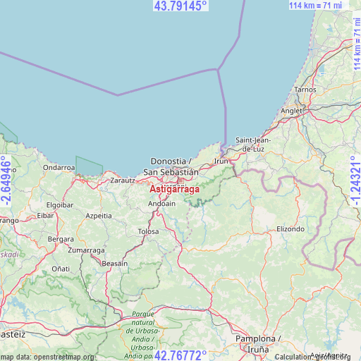
Astigarraga GPS coordinates[2]
43° 16' 54.264" North, 1° 56' 46.824" West
| Map corner | latitude | longitude |
|---|---|---|
| Upper-left | 43.79145°, | -2.64946° |
| Center: | 43.28174°, | -1.94634° |
| Lower-right: | 42.76772°, | -1.24321° |
| Map W x H: | 113.8×113.8 km | = 70.7×70.7mi |
| max Lat: | 43.74134° ⇑2.7% North |
| Astigarraga: | 43.28174° |
| min Lat: | ⇓97.3% South 27.64134° |
| min Long | Astigarraga | max Long |
| -18.00367° | -1.94634° | 4.2899° |
| W 68%⇐ | ⇒32% E |
Elevation
Elevation of Astigarraga is 11 m = 36 ft, and this is 587 m = 1926 ft below average elevation for this country.
| Max E: |
1682 m = 5518 ft | 98.2% |
| Avg. | 598 m = 1962 ft | |
| Astigarraga | 11 m = 36 ft | |
Min E: |
0 m = 0 ft | 1.8% |
See also: Spain elevation on elevation.city.
Geographical zone
Astigarraga is located in North temperate zone (between Tropic of Cancer and the Arctic Circle). Distance of this Northern Tropic circle is 2206.6 km =1371.1 mi to South.| Distance of | km | miles | from Astigarraga |
|---|---|---|---|
| North Pole | 5194.6 | 3227.8 | to North |
| Arctic Circle | 2588.7 | 1608.5 | to North |
| Tropic Cancer | 2206.6 | 1371.1 | to South |
| Equator | 4812.5 | 2990.3 | to South |


Nearby cities:
15 places around Astigarraga: (largest is in red/bold)
• Aduna
12.1 km =7.5 mi,  224°
224°
• Andoain
9.7 km =6 mi, 221°
• Arano
10 km =6.2 mi,  155°
155°
• Donostia / San Sebastián
4.2 km =2.6 mi,  326°
326°
• Errenteria
4.9 km =3 mi,  46°
46°
• Goizueta
13.9 km =8.6 mi,  151°
151°
• Hernani
3 km =1.9 mi,  234°
234°
• Lasarte
6.3 km =3.9 mi,  255°
255°
• Lezo
5.9 km =3.7 mi,  41°
41°
• Oria
6.6 km =4.1 mi,  243°
243°
• Pasaia
5.1 km =3.2 mi,  17°
17°
• Urnieta
5.3 km =3.3 mi, 223°
• Usurbil
8.4 km =5.2 mi, 262°
• Villabona
13.8 km =8.6 mi, 218°
• Zizurkil
13.8 km =8.6 mi, 228°
Sources, notices
• [Note1] Compared only with cities in Spain existing in our database
• [Src1] Map data: © OpenStreetMap contributors (CC-BY-SA)
• [Src2] Other city data from geonames.org with taken over terms of usage.
• [Src3] Geographical zone / Annual Mean Temperature by Robert A. Rohde @ Wikipedia
