Umbrías geodata
Umbrías (Castille and León) is a seat of a third-order administrative division; located in Spain in Europe/Madrid (GMT+2) time zone. With population of 149 people, there are 5436 cities with bigger population in this country. Compared to other cities in Spain, 65.6% of cities are located further ↑North; 79.9% of cities are located further →East and 92.8% of cities have lower elevation than Umbrías. Note1


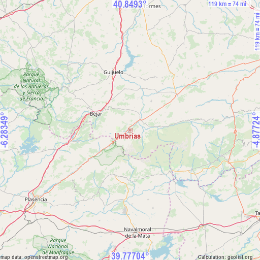
Umbrías GPS coordinates[2]
40° 18' 55.08" North, 5° 34' 49.332" West
| Map corner | latitude | longitude |
|---|---|---|
| Upper-left | 40.8493°, | -6.28349° |
| Center: | 40.3153°, | -5.58037° |
| Lower-right: | 39.77704°, | -4.87724° |
| Map W x H: | 119.2×119.2 km | = 74.1×74.1mi |
| max Lat: | 43.74134° ⇑65.6% North |
| Umbrías: | 40.3153° |
| min Lat: | ⇓34.4% South 27.64134° |
| min Long | Umbrías | max Long |
| -18.00367° | -5.58037° | 4.2899° |
| W 20.1%⇐ | ⇒79.9% E |
Elevation
Elevation of Umbrías is 1088 m = 3570 ft, and this is 490 m = 1608 ft above average elevation for this country.
| Max E: |
1682 m = 5518 ft | 7.2% |
| Umbrías | 1088 m 3570 ft | |
| Avg. | 598 m = 1962 ft | |
Min E: |
0 m = 0 ft | 92.8% |
See also: Spain elevation on elevation.city.
Geographical zone
Umbrías is located in North temperate zone (between Tropic of Cancer and the Arctic Circle). Distance of this Northern Tropic circle is 1876.7 km =1166.1 mi to South.| Distance of | km | miles | from Umbrías |
|---|---|---|---|
| North Pole | 5524.4 | 3432.7 | to North |
| Arctic Circle | 2918.5 | 1813.5 | to North |
| Tropic Cancer | 1876.7 | 1166.1 | to South |
| Equator | 4482.6 | 2785.4 | to South |


Nearby cities:
15 places around Umbrías: (largest is in red/bold)
• Becedas
10.9 km =6.8 mi,  334°
334°
• Bohoyo
11.7 km =7.3 mi,  89°
89°
• El Barco de Ávila
6.7 km =4.2 mi,  45°
45°
• Junciana
10.8 km =6.7 mi,  10°
10°
• La Carrera
4.2 km =2.6 mi,  31°
31°
• Medinilla
14.2 km =8.8 mi,  347°
347°
• Nava del Barco
4.2 km =2.6 mi,  125°
125°
• Navatejares
4.7 km =2.9 mi,  60°
60°
• Neila de San Miguel
13.5 km =8.4 mi, 333°
• Puerto Castilla
4.8 km =3 mi,  230°
230°
• San Bartolomé de Béjar
12.4 km =7.7 mi, 325°
• San Lorenzo de Tormes
9.9 km =6.2 mi, 52°
• Santa María de los Caballeros
13.7 km =8.5 mi, 53°
• Tormellas
5.9 km =3.7 mi,  102°
102°
• Tornavacas
11.4 km =7.1 mi, 233°
Sources, notices
• [Note1] Compared only with cities in Spain existing in our database
• [Src1] Map data: © OpenStreetMap contributors (CC-BY-SA)
• [Src2] Other city data from geonames.org with taken over terms of usage.
• [Src3] Geographical zone / Annual Mean Temperature by Robert A. Rohde @ Wikipedia
