Tornavacas geodata
Tornavacas (Extremadura) is a seat of a third-order administrative division; located in Spain in Europe/Madrid (GMT+2) time zone. With population of 1,279 people, there are 2660 cities with bigger population in this country. Compared to other cities in Spain, 66.3% of cities are located further ↑North; 81.6% of cities are located further →East and 78.9% of cities have lower elevation than Tornavacas. Note1


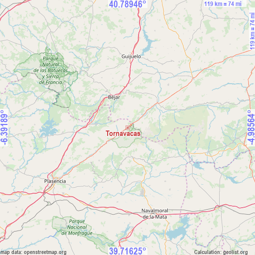
Tornavacas GPS coordinates[2]
40° 15' 17.928" North, 5° 41' 19.536" West
| Map corner | latitude | longitude |
|---|---|---|
| Upper-left | 40.78946°, | -6.39189° |
| Center: | 40.25498°, | -5.68876° |
| Lower-right: | 39.71625°, | -4.98564° |
| Map W x H: | 119.3×119.3 km | = 74.1×74.1mi |
| max Lat: | 43.74134° ⇑66.3% North |
| Tornavacas: | 40.25498° |
| min Lat: | ⇓33.7% South 27.64134° |
| min Long | Tornavacas | max Long |
| -18.00367° | -5.68876° | 4.2899° |
| W 18.4%⇐ | ⇒81.6% E |
Elevation
Elevation of Tornavacas is 888 m = 2913 ft, and this is 290 m = 951 ft above average elevation for this country.
| Max E: |
1682 m = 5518 ft | 21.1% |
| Tornavacas | 888 m 2913 ft | |
| Avg. | 598 m = 1962 ft | |
Min E: |
0 m = 0 ft | 78.9% |
See also: Spain elevation on elevation.city.
Geographical zone
Tornavacas is located in North temperate zone (between Tropic of Cancer and the Arctic Circle). Distance of this Northern Tropic circle is 1870 km =1162 mi to South.| Distance of | km | miles | from Tornavacas |
|---|---|---|---|
| North Pole | 5531.1 | 3436.9 | to North |
| Arctic Circle | 2925.2 | 1817.6 | to North |
| Tropic Cancer | 1870 | 1162 | to South |
| Equator | 4475.9 | 2781.2 | to South |


Nearby cities:
15 places around Tornavacas: (largest is in red/bold)
• Aldeanueva de la Vera
14.3 km =8.9 mi,  184°
184°
• Béjar
15.9 km =9.9 mi,  336°
336°
• Cabezuela del Valle
12.1 km =7.5 mi,  235°
235°
• Candelario
13.4 km =8.3 mi, 339°
• Guijo de Santa Bárbara
11.6 km =7.2 mi,  165°
165°
• Hervás
15.2 km =9.4 mi,  276°
276°
• Jarandilla de la Vera
14.2 km =8.8 mi, 170°
• Jerte
6.3 km =3.9 mi, 235°
• La Carrera
15.3 km =9.5 mi,  47°
47°
• La Garganta
14.1 km =8.8 mi,  305°
305°
• Nava del Barco
13.3 km =8.3 mi,  71°
71°
• Navaconcejo
14.9 km =9.3 mi,  234°
234°
• Navatejares
16 km =9.9 mi,  55°
55°
• Puerto Castilla
6.6 km =4.1 mi, 56°
• Umbrías
11.4 km =7.1 mi, 53°
Sources, notices
• [Note1] Compared only with cities in Spain existing in our database
• [Src1] Map data: © OpenStreetMap contributors (CC-BY-SA)
• [Src2] Other city data from geonames.org with taken over terms of usage.
• [Src3] Geographical zone / Annual Mean Temperature by Robert A. Rohde @ Wikipedia
