Navatejares geodata
Navatejares (Castille and León) is a seat of a third-order administrative division; located in Spain in Europe/Madrid (GMT+2) time zone. With population of 81 people, there are 6123 cities with bigger population in this country. Compared to other cities in Spain, 65.1% of cities are located further ↑North; 79.1% of cities are located further →East and 91% of cities have lower elevation than Navatejares. Note1
Administrative division(s):
- Level 1: Castille and León
- Level 2: Provincia de Ávila
- Level 3: Navatejares


Navatejares GPS coordinates[2]
40° 20' 9.672" North, 5° 31' 55.92" West
| Map corner | latitude | longitude |
|---|---|---|
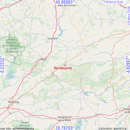
| Upper-left | 40.86985°, | -6.23532° |
| Center: | 40.33602°, | -5.5322° |
| Lower-right: | 39.79793°, | -4.82907° |
| Map W x H: | 119.2×119.2 km | = 74.1×74.1mi |
| max Lat: | 43.74134° ⇑65.1% North |
| Navatejares: | 40.33602° |
| min Lat: | ⇓34.9% South 27.64134° |
| min Long | Navatejares | max Long |
| -18.00367° | -5.5322° | 4.2899° |
| W 20.9%⇐ | ⇒79.1% E |
Elevation
Elevation of Navatejares is 1048 m = 3438 ft, and this is 450 m = 1476 ft above average elevation for this country.
| Max E: |
1682 m = 5518 ft | 9% |
| Navatejares | 1048 m 3438 ft | |
| Avg. | 598 m = 1962 ft | |
Min E: |
0 m = 0 ft | 91% |
See also: Spain elevation on elevation.city.
Geographical zone
Navatejares is located in North temperate zone (between Tropic of Cancer and the Arctic Circle). Distance of this Northern Tropic circle is 1879 km =1167.6 mi to South.| Distance of | km | miles | from Navatejares |
|---|---|---|---|
| North Pole | 5522.1 | 3431.3 | to North |
| Arctic Circle | 2916.2 | 1812 | to North |
| Tropic Cancer | 1879 | 1167.6 | to South |
| Equator | 4484.9 | 2786.8 | to South |


Nearby cities:
15 places around Navatejares: (largest is in red/bold)
• Aldeanueva de Santa Cruz
10.7 km =6.6 mi,  61°
61°
• Avellaneda
13.6 km =8.5 mi, 64°
• Becedas
11.6 km =7.2 mi,  310°
310°
• Bohoyo
7.9 km =4.9 mi,  106°
106°
• El Barco de Ávila
2.5 km =1.6 mi,  17°
17°
• Junciana
8.6 km =5.3 mi,  345°
345°
• La Carrera
2.3 km =1.4 mi,  304°
304°
• La Horcajada
12.5 km =7.8 mi,  26°
26°
• Nava del Barco
4.8 km =3 mi,  188°
188°
• Puerto Castilla
9.4 km =5.8 mi,  235°
235°
• San Bartolomé de Béjar
13.6 km =8.5 mi, 305°
• San Lorenzo de Tormes
5.3 km =3.3 mi,  44°
44°
• Santa María de los Caballeros
9.1 km =5.7 mi,  49°
49°
• Tormellas
4 km =2.5 mi,  154°
154°
• Umbrías
4.7 km =2.9 mi, 240°
Sources, notices
• [Note1] Compared only with cities in Spain existing in our database
• [Src1] Map data: © OpenStreetMap contributors (CC-BY-SA)
• [Src2] Other city data from geonames.org with taken over terms of usage.
• [Src3] Geographical zone / Annual Mean Temperature by Robert A. Rohde @ Wikipedia
