Turégano geodata
Turégano (Castille and León) is a seat of a third-order administrative division; located in Spain in Europe/Madrid (GMT+2) time zone. With population of 1,151 people, there are 2772 cities with bigger population in this country. Compared to other cities in Spain, 52.2% of cities are located further ↓South; 59.8% of cities are located further →East and 83.9% of cities have lower elevation than Turégano. Note1
Administrative division(s):
- Level 1: Castille and León
- Level 2: Provincia de Segovia
- Level 3: Turégano


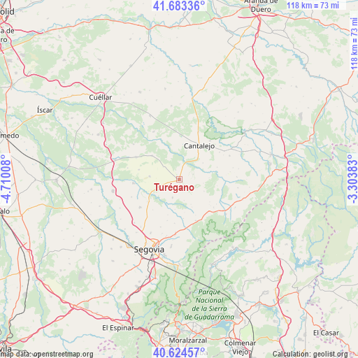
Turégano GPS coordinates[2]
41° 9' 21.96" North, 4° 0' 25.056" West
| Map corner | latitude | longitude |
|---|---|---|
| Upper-left | 41.68336°, | -4.71008° |
| Center: | 41.1561°, | -4.00696° |
| Lower-right: | 40.62457°, | -3.30383° |
| Map W x H: | 117.7×117.7 km | = 73.1×73.1mi |
| max Lat: | 43.74134° ⇑47.8% North |
| Turégano: | 41.1561° |
| min Lat: | ⇓52.2% South 27.64134° |
| min Long | Turégano | max Long |
| -18.00367° | -4.00696° | 4.2899° |
| W 40.2%⇐ | ⇒59.8% E |
Elevation
Elevation of Turégano is 940 m = 3084 ft, and this is 342 m = 1122 ft above average elevation for this country.
| Max E: |
1682 m = 5518 ft | 16.1% |
| Turégano | 940 m 3084 ft | |
| Avg. | 598 m = 1962 ft | |
Min E: |
0 m = 0 ft | 83.9% |
See also: Spain elevation on elevation.city.
Geographical zone
Turégano is located in North temperate zone (between Tropic of Cancer and the Arctic Circle). Distance of this Northern Tropic circle is 1970.2 km =1224.2 mi to South.| Distance of | km | miles | from Turégano |
|---|---|---|---|
| North Pole | 5430.9 | 3374.6 | to North |
| Arctic Circle | 2825 | 1755.4 | to North |
| Tropic Cancer | 1970.2 | 1224.2 | to South |
| Equator | 4576.1 | 2843.5 | to South |


Nearby cities:
15 places around Turégano: (largest is in red/bold)
• Adrada de Pirón
12.1 km =7.5 mi,  197°
197°
• Aguilafuente
11.8 km =7.3 mi,  311°
311°
• Arahuetes
12.8 km =8 mi,  99°
99°
• Arevalillo de Cega
9.9 km =6.2 mi,  86°
86°
• Caballar
5.2 km =3.2 mi,  136°
136°
• Cabezuela
10.9 km =6.8 mi,  35°
35°
• Cubillo
9.1 km =5.7 mi,  115°
115°
• Escalona del Prado
9.8 km =6.1 mi,  277°
277°
• Escobar de Polendos
12.7 km =7.9 mi,  235°
235°
• La Cuesta
9 km =5.6 mi,  154°
154°
• Muñoveros
5 km =3.1 mi,  68°
68°
• Puebla de Pedraza
9.5 km =5.9 mi,  54°
54°
• Sauquillo de Cabezas
6.7 km =4.2 mi, 309°
• Torreiglesias
6.4 km =4 mi, 199°
• Veganzones
4.3 km =2.7 mi,  15°
15°
Sources, notices
• [Note1] Compared only with cities in Spain existing in our database
• [Src1] Map data: © OpenStreetMap contributors (CC-BY-SA)
• [Src2] Other city data from geonames.org with taken over terms of usage.
• [Src3] Geographical zone / Annual Mean Temperature by Robert A. Rohde @ Wikipedia
