Muñoveros geodata
Muñoveros (Castille and León) is a seat of a third-order administrative division; located in Spain in Europe/Madrid (GMT+2) time zone. With population of 196 people, there are 5065 cities with bigger population in this country. Compared to other cities in Spain, 52.6% of cities are located further ↓South; 59% of cities are located further →East and 85.7% of cities have lower elevation than Muñoveros. Note1
Administrative division(s):
- Level 1: Castille and León
- Level 2: Provincia de Segovia
- Level 3: Muñoveros


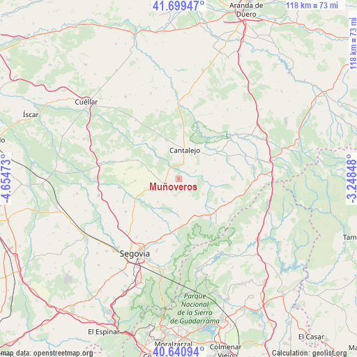
Muñoveros GPS coordinates[2]
41° 10' 20.424" North, 3° 57' 5.796" West
| Map corner | latitude | longitude |
|---|---|---|
| Upper-left | 41.69947°, | -4.65473° |
| Center: | 41.17234°, | -3.95161° |
| Lower-right: | 40.64094°, | -3.24848° |
| Map W x H: | 117.7×117.7 km | = 73.1×73.1mi |
| max Lat: | 43.74134° ⇑47.4% North |
| Muñoveros: | 41.17234° |
| min Lat: | ⇓52.6% South 27.64134° |
| min Long | Muñoveros | max Long |
| -18.00367° | -3.95161° | 4.2899° |
| W 41%⇐ | ⇒59% E |
Elevation
Elevation of Muñoveros is 960 m = 3150 ft, and this is 362 m = 1188 ft above average elevation for this country.
| Max E: |
1682 m = 5518 ft | 14.3% |
| Muñoveros | 960 m 3150 ft | |
| Avg. | 598 m = 1962 ft | |
Min E: |
0 m = 0 ft | 85.7% |
See also: Spain elevation on elevation.city.
Geographical zone
Muñoveros is located in North temperate zone (between Tropic of Cancer and the Arctic Circle). Distance of this Northern Tropic circle is 1972 km =1225.3 mi to South.| Distance of | km | miles | from Muñoveros |
|---|---|---|---|
| North Pole | 5429.1 | 3373.5 | to North |
| Arctic Circle | 2823.2 | 1754.3 | to North |
| Tropic Cancer | 1972 | 1225.3 | to South |
| Equator | 4577.9 | 2844.6 | to South |


Nearby cities:
15 places around Muñoveros: (largest is in red/bold)
• Arahuetes
8.8 km =5.5 mi,  115°
115°
• Arevalillo de Cega
5.4 km =3.4 mi,  102°
102°
• Caballar
5.7 km =3.5 mi,  190°
190°
• Cabezuela
7.3 km =4.5 mi,  13°
13°
• Cantalejo
9.7 km =6 mi, 11°
• Cubillo
6.7 km =4.2 mi,  147°
147°
• La Cuesta
10 km =6.2 mi,  184°
184°
• Puebla de Pedraza
4.9 km =3 mi,  40°
40°
• Rebollo
8.2 km =5.1 mi,  73°
73°
• Sauquillo de Cabezas
10.1 km =6.3 mi,  283°
283°
• Sebúlcor
12.3 km =7.6 mi,  27°
27°
• Torreiglesias
10.3 km =6.4 mi,  221°
221°
• Turégano
5 km =3.1 mi,  248°
248°
• Valleruela de Pedraza
12.1 km =7.5 mi,  86°
86°
• Veganzones
4.2 km =2.6 mi,  303°
303°
Sources, notices
• [Note1] Compared only with cities in Spain existing in our database
• [Src1] Map data: © OpenStreetMap contributors (CC-BY-SA)
• [Src2] Other city data from geonames.org with taken over terms of usage.
• [Src3] Geographical zone / Annual Mean Temperature by Robert A. Rohde @ Wikipedia
