Cubillo geodata
Cubillo (Castille and León) is a seat of a third-order administrative division; located in Spain in Europe/Madrid (GMT+2) time zone. With population of 59 people, there are 6361 cities with bigger population in this country. Compared to other cities in Spain, 51.5% of cities are located further ↓South; 58.3% of cities are located further →East and 91.6% of cities have lower elevation than Cubillo. Note1
Administrative division(s):
- Level 1: Castille and León
- Level 2: Provincia de Segovia
- Level 3: Cubillo


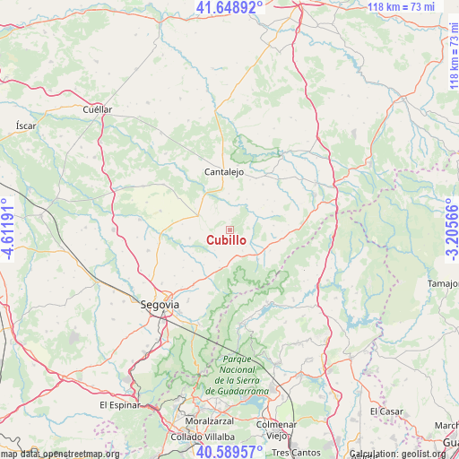
Cubillo GPS coordinates[2]
41° 7' 16.968" North, 3° 54' 31.608" West
| Map corner | latitude | longitude |
|---|---|---|
| Upper-left | 41.64892°, | -4.61191° |
| Center: | 41.12138°, | -3.90878° |
| Lower-right: | 40.58957°, | -3.20566° |
| Map W x H: | 117.8×117.8 km | = 73.2×73.2mi |
| max Lat: | 43.74134° ⇑48.5% North |
| Cubillo: | 41.12138° |
| min Lat: | ⇓51.5% South 27.64134° |
| min Long | Cubillo | max Long |
| -18.00367° | -3.90878° | 4.2899° |
| W 41.7%⇐ | ⇒58.3% E |
Elevation
Elevation of Cubillo is 1061 m = 3481 ft, and this is 463 m = 1519 ft above average elevation for this country.
| Max E: |
1682 m = 5518 ft | 8.4% |
| Cubillo | 1061 m 3481 ft | |
| Avg. | 598 m = 1962 ft | |
Min E: |
0 m = 0 ft | 91.6% |
See also: Spain elevation on elevation.city.
Geographical zone
Cubillo is located in North temperate zone (between Tropic of Cancer and the Arctic Circle). Distance of this Northern Tropic circle is 1966.3 km =1221.8 mi to South.| Distance of | km | miles | from Cubillo |
|---|---|---|---|
| North Pole | 5434.8 | 3377 | to North |
| Arctic Circle | 2828.9 | 1757.8 | to North |
| Tropic Cancer | 1966.3 | 1221.8 | to South |
| Equator | 4572.3 | 2841.1 | to South |


Nearby cities:
15 places around Cubillo: (largest is in red/bold)
• Arahuetes
4.7 km =2.9 mi,  67°
67°
• Arevalillo de Cega
4.8 km =3 mi,  20°
20°
• Caballar
4.6 km =2.9 mi,  270°
270°
• Collado Hermoso
9.2 km =5.7 mi,  185°
185°
• La Cuesta
6.1 km =3.8 mi,  225°
225°
• Muñoveros
6.7 km =4.2 mi,  327°
327°
• Navafría
10.2 km =6.3 mi,  136°
136°
• Pedraza
8.2 km =5.1 mi,  82°
82°
• Pelayos del Arroyo
8.3 km =5.2 mi,  199°
199°
• Puebla de Pedraza
9.4 km =5.8 mi,  357°
357°
• Rebollo
9.1 km =5.7 mi,  28°
28°
• Sotosalbos
9.9 km =6.2 mi, 195°
• Torre Val de San Pedro
6 km =3.7 mi,  148°
148°
• Torreiglesias
10.6 km =6.6 mi,  258°
258°
• Turégano
9.1 km =5.7 mi,  295°
295°
Sources, notices
• [Note1] Compared only with cities in Spain existing in our database
• [Src1] Map data: © OpenStreetMap contributors (CC-BY-SA)
• [Src2] Other city data from geonames.org with taken over terms of usage.
• [Src3] Geographical zone / Annual Mean Temperature by Robert A. Rohde @ Wikipedia
