Foncea geodata
Foncea (La Rioja) is a seat of a third-order administrative division; located in Spain in Europe/Madrid (GMT+2) time zone. With population of 103 people, there are 5896 cities with bigger population in this country. Compared to other cities in Spain, 89.8% of cities are located further ↓South; 53.8% of cities are located further ←West and 53.4% of cities have lower elevation than Foncea. Note1


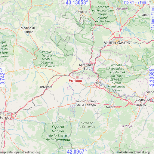
Foncea GPS coordinates[2]
42° 36' 55.044" North, 3° 2' 20.292" West
| Map corner | latitude | longitude |
|---|---|---|
| Upper-left | 43.13058°, | -3.7421° |
| Center: | 42.61529°, | -3.03897° |
| Lower-right: | 42.0957°, | -2.33585° |
| Map W x H: | 115.1×115.1 km | = 71.5×71.5mi |
| max Lat: | 43.74134° ⇑10.2% North |
| Foncea: | 42.61529° |
| min Lat: | ⇓89.8% South 27.64134° |
| min Long | Foncea | max Long |
| -18.00367° | -3.03897° | 4.2899° |
| W 53.8%⇐ | ⇒46.2% E |
Elevation
Elevation of Foncea is 694 m = 2277 ft, and this is 96 m = 315 ft above average elevation for this country.
| Max E: |
1682 m = 5518 ft | 46.6% |
| Foncea | 694 m 2277 ft | |
| Avg. | 598 m = 1962 ft | |
Min E: |
0 m = 0 ft | 53.4% |
See also: Spain elevation on elevation.city.
Geographical zone
Foncea is located in North temperate zone (between Tropic of Cancer and the Arctic Circle). Distance of this Northern Tropic circle is 2132.5 km =1325.1 mi to South.| Distance of | km | miles | from Foncea |
|---|---|---|---|
| North Pole | 5268.7 | 3273.8 | to North |
| Arctic Circle | 2662.8 | 1654.6 | to North |
| Tropic Cancer | 2132.5 | 1325.1 | to South |
| Equator | 4738.4 | 2944.3 | to South |


Nearby cities:
15 places around Foncea: (largest is in red/bold)
• Altable
3.4 km =2.1 mi,  245°
245°
• Ameyugo
4.9 km =3 mi,  337°
337°
• Bugedo
4.1 km =2.5 mi,  24°
24°
• Cellorigo
3.4 km =2.1 mi,  67°
67°
• Cuzcurrita de Río Tirón
10.2 km =6.3 mi,  143°
143°
• Encío
7.3 km =4.5 mi,  327°
327°
• Fonzaleche
4.4 km =2.7 mi,  149°
149°
• Galbárruli
6.4 km =4 mi,  83°
83°
• Ochánduri
10.4 km =6.5 mi,  164°
164°
• Pancorbo
6.3 km =3.9 mi,  289°
289°
• Sajazarra
7 km =4.3 mi,  114°
114°
• San Millán de Yécora
8.9 km =5.5 mi,  211°
211°
• Tirgo
10.6 km =6.6 mi, 136°
• Treviana
6.3 km =3.9 mi,  188°
188°
• Valluércanes
8.3 km =5.2 mi,  234°
234°
Sources, notices
• [Note1] Compared only with cities in Spain existing in our database
• [Src1] Map data: © OpenStreetMap contributors (CC-BY-SA)
• [Src2] Other city data from geonames.org with taken over terms of usage.
• [Src3] Geographical zone / Annual Mean Temperature by Robert A. Rohde @ Wikipedia
