Cellorigo geodata
Cellorigo (La Rioja) is a seat of a third-order administrative division; located in Spain in Europe/Madrid (GMT+2) time zone. With population of 23 people, there are 6702 cities with bigger population in this country. Compared to other cities in Spain, 90.2% of cities are located further ↓South; 54.5% of cities are located further ←West and 63.6% of cities have lower elevation than Cellorigo. Note1


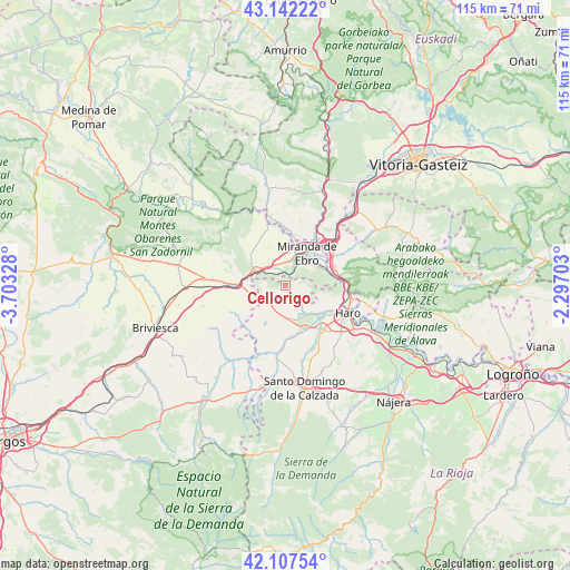
Cellorigo GPS coordinates[2]
42° 37' 37.308" North, 3° 0' 0.576" West
| Map corner | latitude | longitude |
|---|---|---|
| Upper-left | 43.14222°, | -3.70328° |
| Center: | 42.62703°, | -3.00016° |
| Lower-right: | 42.10754°, | -2.29703° |
| Map W x H: | 115×115 km | = 71.5×71.5mi |
| max Lat: | 43.74134° ⇑9.8% North |
| Cellorigo: | 42.62703° |
| min Lat: | ⇓90.2% South 27.64134° |
| min Long | Cellorigo | max Long |
| -18.00367° | -3.00016° | 4.2899° |
| W 54.5%⇐ | ⇒45.5% E |
Elevation
Elevation of Cellorigo is 768 m = 2520 ft, and this is 170 m = 558 ft above average elevation for this country.
| Max E: |
1682 m = 5518 ft | 36.4% |
| Cellorigo | 768 m 2520 ft | |
| Avg. | 598 m = 1962 ft | |
Min E: |
0 m = 0 ft | 63.6% |
See also: Spain elevation on elevation.city.
Geographical zone
Cellorigo is located in North temperate zone (between Tropic of Cancer and the Arctic Circle). Distance of this Northern Tropic circle is 2133.8 km =1325.9 mi to South.| Distance of | km | miles | from Cellorigo |
|---|---|---|---|
| North Pole | 5267.4 | 3273 | to North |
| Arctic Circle | 2661.5 | 1653.8 | to North |
| Tropic Cancer | 2133.8 | 1325.9 | to South |
| Equator | 4739.7 | 2945.1 | to South |


Nearby cities:
15 places around Cellorigo: (largest is in red/bold)
• Altable
6.9 km =4.3 mi,  246°
246°
• Ameyugo
6 km =3.7 mi,  302°
302°
• Anguciana
10 km =6.2 mi,  125°
125°
• Bugedo
2.9 km =1.8 mi,  329°
329°
• Cihuri
9.4 km =5.8 mi,  137°
137°
• Encío
8.6 km =5.3 mi, 304°
• Foncea
3.4 km =2.1 mi, 247°
• Fonzaleche
5.2 km =3.2 mi,  190°
190°
• Galbárruli
3.3 km =2.1 mi,  100°
100°
• Miranda de Ebro
7.9 km =4.9 mi,  33°
33°
• Pancorbo
9.2 km =5.7 mi,  274°
274°
• Sajazarra
5.3 km =3.3 mi, 143°
• Tirgo
9.9 km =6.2 mi,  155°
155°
• Treviana
8.6 km =5.3 mi,  208°
208°
• Villalba de Rioja
9.5 km =5.9 mi, 101°
Sources, notices
• [Note1] Compared only with cities in Spain existing in our database
• [Src1] Map data: © OpenStreetMap contributors (CC-BY-SA)
• [Src2] Other city data from geonames.org with taken over terms of usage.
• [Src3] Geographical zone / Annual Mean Temperature by Robert A. Rohde @ Wikipedia
