Fonzaleche geodata
Fonzaleche (La Rioja) is a seat of a third-order administrative division; located in Spain in Europe/Madrid (GMT+2) time zone. With population of 163 people, there are 5323 cities with bigger population in this country. Compared to other cities in Spain, 89% of cities are located further ↓South; 54.2% of cities are located further ←West and 57.7% of cities have higher elevation than Fonzaleche. Note1


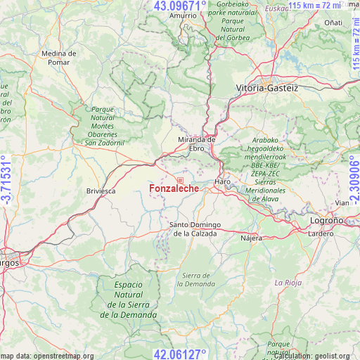
Fonzaleche GPS coordinates[2]
42° 34' 52.104" North, 3° 0' 43.848" West
| Map corner | latitude | longitude |
|---|---|---|
| Upper-left | 43.09671°, | -3.71531° |
| Center: | 42.58114°, | -3.01218° |
| Lower-right: | 42.06127°, | -2.30906° |
| Map W x H: | 115.1×115.1 km | = 71.5×71.5mi |
| max Lat: | 43.74134° ⇑11% North |
| Fonzaleche: | 42.58114° |
| min Lat: | ⇓89% South 27.64134° |
| min Long | Fonzaleche | max Long |
| -18.00367° | -3.01218° | 4.2899° |
| W 54.2%⇐ | ⇒45.8% E |
Elevation
Elevation of Fonzaleche is 555 m = 1821 ft, and this is 43 m = 141 ft below average elevation for this country.
| Max E: |
1682 m = 5518 ft | 57.7% |
| Avg. | 598 m = 1962 ft | |
| Fonzaleche | 555 m = 1821 ft | |
Min E: |
0 m = 0 ft | 42.3% |
See also: Spain elevation on elevation.city.
Geographical zone
Fonzaleche is located in North temperate zone (between Tropic of Cancer and the Arctic Circle). Distance of this Northern Tropic circle is 2128.7 km =1322.7 mi to South.| Distance of | km | miles | from Fonzaleche |
|---|---|---|---|
| North Pole | 5272.5 | 3276.2 | to North |
| Arctic Circle | 2666.6 | 1656.9 | to North |
| Tropic Cancer | 2128.7 | 1322.7 | to South |
| Equator | 4734.6 | 2941.9 | to South |


Nearby cities:
15 places around Fonzaleche: (largest is in red/bold)
• Altable
5.8 km =3.6 mi,  294°
294°
• Anguciana
9.1 km =5.7 mi,  94°
94°
• Bugedo
7.6 km =4.7 mi,  356°
356°
• Cellorigo
5.2 km =3.2 mi,  10°
10°
• Cihuri
7.5 km =4.7 mi,  103°
103°
• Cuzcurrita de Río Tirón
5.9 km =3.7 mi,  138°
138°
• Foncea
4.4 km =2.7 mi,  329°
329°
• Galbárruli
6.2 km =3.9 mi,  42°
42°
• Herramélluri
8.7 km =5.4 mi,  183°
183°
• Ochánduri
6.2 km =3.9 mi,  173°
173°
• Sajazarra
4.3 km =2.7 mi,  78°
78°
• San Millán de Yécora
7.9 km =4.9 mi,  241°
241°
• Tirgo
6.5 km =4 mi,  127°
127°
• Treviana
4 km =2.5 mi,  231°
231°
• Valluércanes
9 km =5.6 mi,  263°
263°
Sources, notices
• [Note1] Compared only with cities in Spain existing in our database
• [Src1] Map data: © OpenStreetMap contributors (CC-BY-SA)
• [Src2] Other city data from geonames.org with taken over terms of usage.
• [Src3] Geographical zone / Annual Mean Temperature by Robert A. Rohde @ Wikipedia
