Torrehermosa geodata
Torrehermosa (Aragon) is a seat of a third-order administrative division; located in Spain in Europe/Madrid (GMT+2) time zone. With population of 98 people, there are 5963 cities with bigger population in this country. Compared to other cities in Spain, 54.2% of cities are located further ↓South; 65.8% of cities are located further ←West and 73.1% of cities have lower elevation than Torrehermosa. Note1


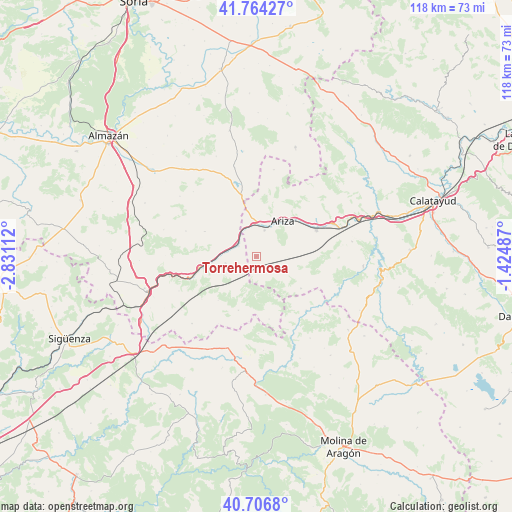
Torrehermosa GPS coordinates[2]
41° 14' 15.612" North, 2° 7' 40.8" West
| Map corner | latitude | longitude |
|---|---|---|
| Upper-left | 41.76427°, | -2.83112° |
| Center: | 41.23767°, | -2.128° |
| Lower-right: | 40.7068°, | -1.42487° |
| Map W x H: | 117.6×117.6 km | = 73.1×73.1mi |
| max Lat: | 43.74134° ⇑45.8% North |
| Torrehermosa: | 41.23767° |
| min Lat: | ⇓54.2% South 27.64134° |
| min Long | Torrehermosa | max Long |
| -18.00367° | -2.128° | 4.2899° |
| W 65.8%⇐ | ⇒34.2% E |
Elevation
Elevation of Torrehermosa is 836 m = 2743 ft, and this is 238 m = 781 ft above average elevation for this country.
| Max E: |
1682 m = 5518 ft | 26.9% |
| Torrehermosa | 836 m 2743 ft | |
| Avg. | 598 m = 1962 ft | |
Min E: |
0 m = 0 ft | 73.1% |
See also: Spain elevation on elevation.city.
Geographical zone
Torrehermosa is located in North temperate zone (between Tropic of Cancer and the Arctic Circle). Distance of this Northern Tropic circle is 1979.3 km =1229.9 mi to South.| Distance of | km | miles | from Torrehermosa |
|---|---|---|---|
| North Pole | 5421.9 | 3369 | to North |
| Arctic Circle | 2816 | 1749.8 | to North |
| Tropic Cancer | 1979.3 | 1229.9 | to South |
| Equator | 4585.2 | 2849.1 | to South |


Nearby cities:
15 places around Torrehermosa: (largest is in red/bold)
• Alconchel de Ariza
3.7 km =2.3 mi,  172°
172°
• Algar de Mesa
18.1 km =11.2 mi,  129°
129°
• Almaluez
13.1 km =8.1 mi,  296°
296°
• Arcos de Jalón
12.5 km =7.8 mi,  258°
258°
• Ariza
10.6 km =6.6 mi,  36°
36°
• Cabolafuente
7.9 km =4.9 mi,  112°
112°
• Cetina
15.1 km =9.4 mi,  66°
66°
• Contamina
19.1 km =11.9 mi, 66°
• Mochales
18.3 km =11.4 mi,  149°
149°
• Monreal de Ariza
6.3 km =3.9 mi,  17°
17°
• Monteagudo de las Vicarías
14.6 km =9.1 mi,  346°
346°
• Pozuel de Ariza
12.6 km =7.8 mi, 351°
• Santa María de Huerta
4.6 km =2.9 mi,  314°
314°
• Sisamón
12.7 km =7.9 mi, 125°
• Villel de Mesa
16.9 km =10.5 mi,  137°
137°
Sources, notices
• [Note1] Compared only with cities in Spain existing in our database
• [Src1] Map data: © OpenStreetMap contributors (CC-BY-SA)
• [Src2] Other city data from geonames.org with taken over terms of usage.
• [Src3] Geographical zone / Annual Mean Temperature by Robert A. Rohde @ Wikipedia
