Almaluez geodata
Almaluez (Castille and León) is a seat of a third-order administrative division; located in Spain in Europe/Madrid (GMT+2) time zone. With population of 243 people, there are 4788 cities with bigger population in this country. Compared to other cities in Spain, 55.1% of cities are located further ↓South; 63.9% of cities are located further ←West and 71.2% of cities have lower elevation than Almaluez. Note1
Administrative division(s):
- Level 1: Castille and León
- Level 2: Provincia de Soria
- Level 3: Almaluez


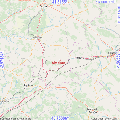
Almaluez GPS coordinates[2]
41° 17' 21.552" North, 2° 16' 7.356" West
| Map corner | latitude | longitude |
|---|---|---|
| Upper-left | 41.8155°, | -2.97184° |
| Center: | 41.28932°, | -2.26871° |
| Lower-right: | 40.75886°, | -1.56559° |
| Map W x H: | 117.5×117.5 km | = 73×73mi |
| max Lat: | 43.74134° ⇑44.9% North |
| Almaluez: | 41.28932° |
| min Lat: | ⇓55.1% South 27.64134° |
| min Long | Almaluez | max Long |
| -18.00367° | -2.26871° | 4.2899° |
| W 63.9%⇐ | ⇒36.1% E |
Elevation
Elevation of Almaluez is 822 m = 2697 ft, and this is 224 m = 735 ft above average elevation for this country.
| Max E: |
1682 m = 5518 ft | 28.8% |
| Almaluez | 822 m 2697 ft | |
| Avg. | 598 m = 1962 ft | |
Min E: |
0 m = 0 ft | 71.2% |
See also: Spain elevation on elevation.city.
Geographical zone
Almaluez is located in North temperate zone (between Tropic of Cancer and the Arctic Circle). Distance of this Northern Tropic circle is 1985 km =1233.4 mi to South.| Distance of | km | miles | from Almaluez |
|---|---|---|---|
| North Pole | 5416.1 | 3365.4 | to North |
| Arctic Circle | 2810.2 | 1746.2 | to North |
| Tropic Cancer | 1985 | 1233.4 | to South |
| Equator | 4590.9 | 2852.7 | to South |


Nearby cities:
15 places around Almaluez: (largest is in red/bold)
• Adradas
18.4 km =11.4 mi,  291°
291°
• Alconchel de Ariza
15.5 km =9.6 mi,  127°
127°
• Alentisque
15.5 km =9.6 mi,  340°
340°
• Arcos de Jalón
8.2 km =5.1 mi,  183°
183°
• Ariza
18.2 km =11.3 mi,  81°
81°
• Cañamaque
17.4 km =10.8 mi,  8°
8°
• Medinaceli
19 km =11.8 mi,  226°
226°
• Momblona
18.4 km =11.4 mi, 339°
• Monreal de Ariza
13.7 km =8.5 mi,  88°
88°
• Monteagudo de las Vicarías
11.8 km =7.3 mi,  44°
44°
• Morón de Almazán
18.3 km =11.4 mi,  318°
318°
• Pozuel de Ariza
12 km =7.5 mi,  55°
55°
• Santa María de Huerta
8.9 km =5.5 mi,  106°
106°
• Taroda
15.2 km =9.4 mi,  295°
295°
• Torrehermosa
13.1 km =8.1 mi,  116°
116°
Sources, notices
• [Note1] Compared only with cities in Spain existing in our database
• [Src1] Map data: © OpenStreetMap contributors (CC-BY-SA)
• [Src2] Other city data from geonames.org with taken over terms of usage.
• [Src3] Geographical zone / Annual Mean Temperature by Robert A. Rohde @ Wikipedia
