Cabolafuente geodata
Cabolafuente (Aragon) is a seat of a third-order administrative division; located in Spain in Europe/Madrid (GMT+2) time zone. With population of 66 people, there are 6282 cities with bigger population in this country. Compared to other cities in Spain, 53.4% of cities are located further ↓South; 67% of cities are located further ←West and 84.6% of cities have lower elevation than Cabolafuente. Note1


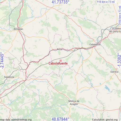
Cabolafuente GPS coordinates[2]
41° 12' 37.908" North, 2° 2' 28.788" West
| Map corner | latitude | longitude |
|---|---|---|
| Upper-left | 41.73735°, | -2.74445° |
| Center: | 41.21053°, | -2.04133° |
| Lower-right: | 40.67944°, | -1.3382° |
| Map W x H: | 117.6×117.6 km | = 73.1×73.1mi |
| max Lat: | 43.74134° ⇑46.6% North |
| Cabolafuente: | 41.21053° |
| min Lat: | ⇓53.4% South 27.64134° |
| min Long | Cabolafuente | max Long |
| -18.00367° | -2.04133° | 4.2899° |
| W 67%⇐ | ⇒33% E |
Elevation
Elevation of Cabolafuente is 946 m = 3104 ft, and this is 348 m = 1142 ft above average elevation for this country.
| Max E: |
1682 m = 5518 ft | 15.4% |
| Cabolafuente | 946 m 3104 ft | |
| Avg. | 598 m = 1962 ft | |
Min E: |
0 m = 0 ft | 84.6% |
See also: Spain elevation on elevation.city.
Geographical zone
Cabolafuente is located in North temperate zone (between Tropic of Cancer and the Arctic Circle). Distance of this Northern Tropic circle is 1976.3 km =1228 mi to South.| Distance of | km | miles | from Cabolafuente |
|---|---|---|---|
| North Pole | 5424.9 | 3370.9 | to North |
| Arctic Circle | 2819 | 1751.6 | to North |
| Tropic Cancer | 1976.3 | 1228 | to South |
| Equator | 4582.2 | 2847.2 | to South |


Nearby cities:
15 places around Cabolafuente: (largest is in red/bold)
• Alconchel de Ariza
6.8 km =4.2 mi,  264°
264°
• Algar de Mesa
10.8 km =6.7 mi,  140°
140°
• Alhama de Aragón
15.6 km =9.7 mi,  52°
52°
• Ariza
11.6 km =7.2 mi,  355°
355°
• Calmarza
12.3 km =7.6 mi,  118°
118°
• Cetina
11.2 km =7 mi,  35°
35°
• Contamina
14.8 km =9.2 mi, 44°
• Godojos
16.2 km =10.1 mi,  66°
66°
• Jaraba
13.3 km =8.3 mi,  99°
99°
• Mochales
12.9 km =8 mi,  170°
170°
• Monreal de Ariza
10.5 km =6.5 mi,  329°
329°
• Santa María de Huerta
12.2 km =7.6 mi,  300°
300°
• Sisamón
5.4 km =3.4 mi, 144°
• Torrehermosa
7.9 km =4.9 mi,  292°
292°
• Villel de Mesa
10.3 km =6.4 mi,  155°
155°
Sources, notices
• [Note1] Compared only with cities in Spain existing in our database
• [Src1] Map data: © OpenStreetMap contributors (CC-BY-SA)
• [Src2] Other city data from geonames.org with taken over terms of usage.
• [Src3] Geographical zone / Annual Mean Temperature by Robert A. Rohde @ Wikipedia
