Cetina geodata
Cetina (Aragon) is a seat of a third-order administrative division; located in Spain in Europe/Madrid (GMT+2) time zone. With population of 715 people, there are 3377 cities with bigger population in this country. Compared to other cities in Spain, 55.2% of cities are located further ↓South; 67.9% of cities are located further ←West and 52.6% of cities have lower elevation than Cetina. Note1


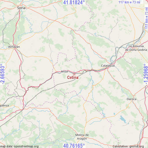
Cetina GPS coordinates[2]
41° 17' 31.488" North, 1° 57' 46.116" West
| Map corner | latitude | longitude |
|---|---|---|
| Upper-left | 41.81824°, | -2.66593° |
| Center: | 41.29208°, | -1.96281° |
| Lower-right: | 40.76165°, | -1.25968° |
| Map W x H: | 117.5×117.5 km | = 73×73mi |
| max Lat: | 43.74134° ⇑44.8% North |
| Cetina: | 41.29208° |
| min Lat: | ⇓55.2% South 27.64134° |
| min Long | Cetina | max Long |
| -18.00367° | -1.96281° | 4.2899° |
| W 67.9%⇐ | ⇒32.1% E |
Elevation
Elevation of Cetina is 686 m = 2251 ft, and this is 88 m = 289 ft above average elevation for this country.
| Max E: |
1682 m = 5518 ft | 47.4% |
| Cetina | 686 m 2251 ft | |
| Avg. | 598 m = 1962 ft | |
Min E: |
0 m = 0 ft | 52.6% |
See also: Spain elevation on elevation.city.
Geographical zone
Cetina is located in North temperate zone (between Tropic of Cancer and the Arctic Circle). Distance of this Northern Tropic circle is 1985.3 km =1233.6 mi to South.| Distance of | km | miles | from Cetina |
|---|---|---|---|
| North Pole | 5415.8 | 3365.2 | to North |
| Arctic Circle | 2809.9 | 1746 | to North |
| Tropic Cancer | 1985.3 | 1233.6 | to South |
| Equator | 4591.2 | 2852.8 | to South |


Nearby cities:
15 places around Cetina: (largest is in red/bold)
• Alhama de Aragón
5.8 km =3.6 mi,  85°
85°
• Ariza
8 km =5 mi,  288°
288°
• Ateca
14.8 km =9.2 mi,  73°
73°
• Bubierca
9.4 km =5.8 mi, 74°
• Cabolafuente
11.2 km =7 mi,  215°
215°
• Carenas
13.9 km =8.6 mi,  96°
96°
• Castejón de las Armas
12.8 km =8 mi,  81°
81°
• Cihuela
13.2 km =8.2 mi,  346°
346°
• Contamina
4.1 km =2.5 mi, 68°
• Embid de Ariza
9.6 km =6 mi, 354°
• Godojos
8.7 km =5.4 mi,  107°
107°
• Ibdes
13.7 km =8.5 mi,  127°
127°
• Jaraba
13 km =8.1 mi,  149°
149°
• Monreal de Ariza
11.9 km =7.4 mi,  269°
269°
• Sisamón
13.9 km =8.6 mi,  194°
194°
Sources, notices
• [Note1] Compared only with cities in Spain existing in our database
• [Src1] Map data: © OpenStreetMap contributors (CC-BY-SA)
• [Src2] Other city data from geonames.org with taken over terms of usage.
• [Src3] Geographical zone / Annual Mean Temperature by Robert A. Rohde @ Wikipedia
