Morella geodata
Morella (Valencia) is a seat of a third-order administrative division; located in Spain in Europe/Madrid (GMT+2) time zone. With population of 2,797 people, there are 1783 cities with bigger population in this country. Compared to other cities in Spain, 59.4% of cities are located further ↑North; 86.4% of cities are located further ←West and 86.5% of cities have lower elevation than Morella. Note1


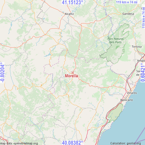
Morella GPS coordinates[2]
40° 37' 10.776" North, 0° 5' 56.112" West
| Map corner | latitude | longitude |
|---|---|---|
| Upper-left | 41.15123°, | -0.80204° |
| Center: | 40.61966°, | -0.09892° |
| Lower-right: | 40.08382°, | 0.60421° |
| Map W x H: | 118.7×118.7 km | = 73.8×73.8mi |
| max Lat: | 43.74134° ⇑59.4% North |
| Morella: | 40.61966° |
| min Lat: | ⇓40.6% South 27.64134° |
| min Long | Morella | max Long |
| -18.00367° | -0.09892° | 4.2899° |
| W 86.4%⇐ | ⇒13.6% E |
Elevation
Elevation of Morella is 972 m = 3189 ft, and this is 374 m = 1227 ft above average elevation for this country.
| Max E: |
1682 m = 5518 ft | 13.5% |
| Morella | 972 m 3189 ft | |
| Avg. | 598 m = 1962 ft | |
Min E: |
0 m = 0 ft | 86.5% |
See also: Spain elevation on elevation.city.
Geographical zone
Morella is located in North temperate zone (between Tropic of Cancer and the Arctic Circle). Distance of this Northern Tropic circle is 1910.6 km =1187.2 mi to South.| Distance of | km | miles | from Morella |
|---|---|---|---|
| North Pole | 5490.6 | 3411.7 | to North |
| Arctic Circle | 2884.7 | 1792.5 | to North |
| Tropic Cancer | 1910.6 | 1187.2 | to South |
| Equator | 4516.5 | 2806.4 | to South |


Nearby cities:
15 places around Morella: (largest is in red/bold)
• Ares del Maestre
18.3 km =11.4 mi,  188°
188°
• Castell de Cabres
12.7 km =7.9 mi,  69°
69°
• Castellfort
15.2 km =9.4 mi,  210°
210°
• Cinctorres
10.7 km =6.6 mi,  247°
247°
• Forcall
9 km =5.6 mi,  288°
288°
• Herbés
13.8 km =8.6 mi,  35°
35°
• Monroyo
19.4 km =12.1 mi,  15°
15°
• Palanques
12.9 km =8 mi,  328°
328°
• Peñarroya de Tastavíns
19.2 km =11.9 mi, 37°
• Portell de Morella
16.9 km =10.5 mi,  235°
235°
• Todolella
12.8 km =8 mi,  283°
283°
• Torre de Arcas
14.9 km =9.3 mi,  9°
9°
• Vallibona
12.4 km =7.7 mi,  98°
98°
• Villores
10.5 km =6.5 mi,  305°
305°
• Zorita del Maestrazgo
13.3 km =8.3 mi, 334°
Sources, notices
• [Note1] Compared only with cities in Spain existing in our database
• [Src1] Map data: © OpenStreetMap contributors (CC-BY-SA)
• [Src2] Other city data from geonames.org with taken over terms of usage.
• [Src3] Geographical zone / Annual Mean Temperature by Robert A. Rohde @ Wikipedia
