Taroda geodata
Taroda (Castille and León) is a seat of a third-order administrative division; located in Spain in Europe/Madrid (GMT+2) time zone. With population of 75 people, there are 6194 cities with bigger population in this country. Compared to other cities in Spain, 56.2% of cities are located further ↓South; 61.8% of cities are located further ←West and 89.9% of cities have lower elevation than Taroda. Note1


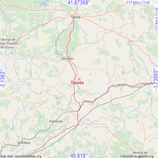
Taroda GPS coordinates[2]
41° 20' 52.728" North, 2° 25' 59.448" West
| Map corner | latitude | longitude |
|---|---|---|
| Upper-left | 41.87368°, | -3.1363° |
| Center: | 41.34798°, | -2.43318° |
| Lower-right: | 40.818°, | -1.73005° |
| Map W x H: | 117.4×117.4 km | = 72.9×72.9mi |
| max Lat: | 43.74134° ⇑43.8% North |
| Taroda: | 41.34798° |
| min Lat: | ⇓56.2% South 27.64134° |
| min Long | Taroda | max Long |
| -18.00367° | -2.43318° | 4.2899° |
| W 61.8%⇐ | ⇒38.2% E |
Elevation
Elevation of Taroda is 1030 m = 3379 ft, and this is 432 m = 1417 ft above average elevation for this country.
| Max E: |
1682 m = 5518 ft | 10.1% |
| Taroda | 1030 m 3379 ft | |
| Avg. | 598 m = 1962 ft | |
Min E: |
0 m = 0 ft | 89.9% |
See also: Spain elevation on elevation.city.
Geographical zone
Taroda is located in North temperate zone (between Tropic of Cancer and the Arctic Circle). Distance of this Northern Tropic circle is 1991.5 km =1237.5 mi to South.| Distance of | km | miles | from Taroda |
|---|---|---|---|
| North Pole | 5409.6 | 3361.4 | to North |
| Arctic Circle | 2803.7 | 1742.1 | to North |
| Tropic Cancer | 1991.5 | 1237.5 | to South |
| Equator | 4597.5 | 2856.8 | to South |


Nearby cities:
15 places around Taroda: (largest is in red/bold)
• Adradas
3.4 km =2.1 mi,  275°
275°
• Alcubilla de las Peñas
13.3 km =8.3 mi,  216°
216°
• Alentisque
11.7 km =7.3 mi,  46°
46°
• Almaluez
15.2 km =9.4 mi,  115°
115°
• Almazán
17.4 km =10.8 mi,  332°
332°
• Cañamaque
19.5 km =12.1 mi,  56°
56°
• Coscurita
10.3 km =6.4 mi,  339°
339°
• Escobosa de Almazán
16.2 km =10.1 mi,  18°
18°
• Frechilla de Almazán
11.1 km =6.9 mi,  322°
322°
• Maján
17.3 km =10.7 mi,  38°
38°
• Momblona
12.9 km =8 mi,  34°
34°
• Morón de Almazán
7.5 km =4.7 mi,  12°
12°
• Soliedra
14.2 km =8.8 mi, 17°
• Villasayas
14.8 km =9.2 mi,  272°
272°
• Yelo
16.2 km =10.1 mi,  205°
205°
Sources, notices
• [Note1] Compared only with cities in Spain existing in our database
• [Src1] Map data: © OpenStreetMap contributors (CC-BY-SA)
• [Src2] Other city data from geonames.org with taken over terms of usage.
• [Src3] Geographical zone / Annual Mean Temperature by Robert A. Rohde @ Wikipedia
