Momblona geodata
Momblona (Castille and León) is a seat of a third-order administrative division; located in Spain in Europe/Madrid (GMT+2) time zone. With population of 36 people, there are 6610 cities with bigger population in this country. Compared to other cities in Spain, 59.4% of cities are located further ↓South; 62.9% of cities are located further ←West and 91.8% of cities have lower elevation than Momblona. Note1
Administrative division(s):
- Level 1: Castille and León
- Level 2: Provincia de Soria
- Level 3: Momblona


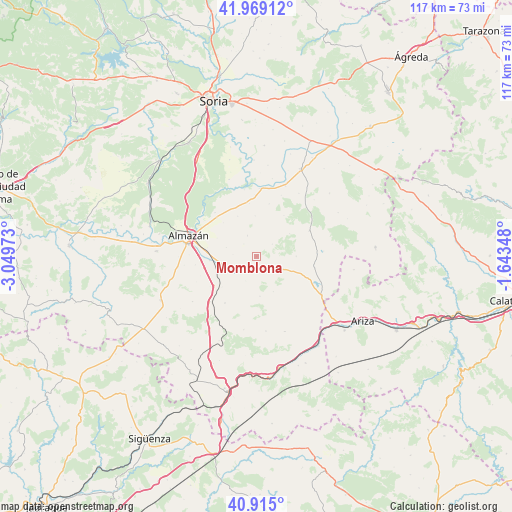
Momblona GPS coordinates[2]
41° 26' 39.12" North, 2° 20' 47.76" West
| Map corner | latitude | longitude |
|---|---|---|
| Upper-left | 41.96912°, | -3.04973° |
| Center: | 41.4442°, | -2.3466° |
| Lower-right: | 40.915°, | -1.64348° |
| Map W x H: | 117.2×117.2 km | = 72.8×72.8mi |
| max Lat: | 43.74134° ⇑40.6% North |
| Momblona: | 41.4442° |
| min Lat: | ⇓59.4% South 27.64134° |
| min Long | Momblona | max Long |
| -18.00367° | -2.3466° | 4.2899° |
| W 62.9%⇐ | ⇒37.1% E |
Elevation
Elevation of Momblona is 1064 m = 3491 ft, and this is 466 m = 1529 ft above average elevation for this country.
| Max E: |
1682 m = 5518 ft | 8.2% |
| Momblona | 1064 m 3491 ft | |
| Avg. | 598 m = 1962 ft | |
Min E: |
0 m = 0 ft | 91.8% |
See also: Spain elevation on elevation.city.
Geographical zone
Momblona is located in North temperate zone (between Tropic of Cancer and the Arctic Circle). Distance of this Northern Tropic circle is 2002.2 km =1244.1 mi to South.| Distance of | km | miles | from Momblona |
|---|---|---|---|
| North Pole | 5398.9 | 3354.7 | to North |
| Arctic Circle | 2793 | 1735.5 | to North |
| Tropic Cancer | 2002.2 | 1244.1 | to South |
| Equator | 4608.2 | 2863.4 | to South |


Nearby cities:
15 places around Momblona: (largest is in red/bold)
• Alentisque
2.9 km =1.8 mi,  154°
154°
• Bliecos
11.2 km =7 mi,  33°
33°
• Borjabad
12.1 km =7.5 mi,  352°
352°
• Cañamaque
9.1 km =5.7 mi,  89°
89°
• Coscurita
10.8 km =6.7 mi,  264°
264°
• Escobosa de Almazán
5.1 km =3.2 mi,  336°
336°
• Frechilla de Almazán
14.1 km =8.8 mi, 262°
• Maján
4.6 km =2.9 mi,  53°
53°
• Morón de Almazán
6.5 km =4 mi,  238°
238°
• Nepas
10.1 km =6.3 mi,  334°
334°
• Nolay
9.2 km =5.7 mi,  357°
357°
• Soliedra
4 km =2.5 mi,  313°
313°
• Taroda
12.9 km =8 mi,  214°
214°
• Velilla de los Ajos
9.2 km =5.7 mi,  55°
55°
• Viana de Duero
13.8 km =8.6 mi,  316°
316°
Sources, notices
• [Note1] Compared only with cities in Spain existing in our database
• [Src1] Map data: © OpenStreetMap contributors (CC-BY-SA)
• [Src2] Other city data from geonames.org with taken over terms of usage.
• [Src3] Geographical zone / Annual Mean Temperature by Robert A. Rohde @ Wikipedia
