Figueras geodata
Figueras (Asturias) is a populated place; located in Spain in Europe/Madrid (GMT+2) time zone. With population of 714 people, there are 3379 cities with bigger population in this country. Compared to other cities in Spain, 99.7% of cities are located further ↓South; 94.4% of cities are located further →East and 98.9% of cities have higher elevation than Figueras. Note1


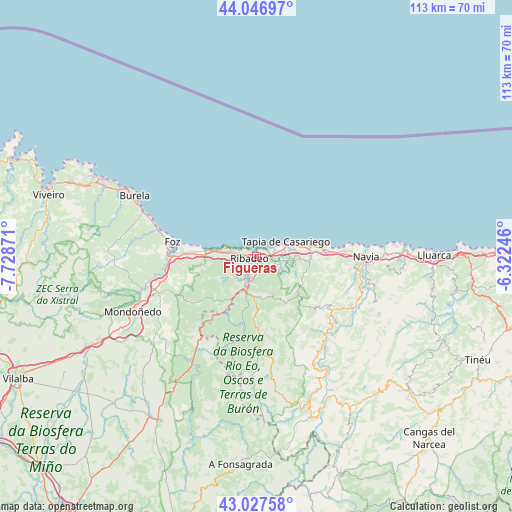
Figueras GPS coordinates[2]
43° 32' 21.948" North, 7° 1' 32.124" West
| Map corner | latitude | longitude |
|---|---|---|
| Upper-left | 44.04697°, | -7.72871° |
| Center: | 43.53943°, | -7.02559° |
| Lower-right: | 43.02758°, | -6.32246° |
| Map W x H: | 113.3×113.3 km | = 70.4×70.4mi |
| max Lat: | 43.74134° ⇑0.3% North |
| Figueras: | 43.53943° |
| min Lat: | ⇓99.7% South 27.64134° |
| min Long | Figueras | max Long |
| -18.00367° | -7.02559° | 4.2899° |
| W 5.6%⇐ | ⇒94.4% E |
Elevation
Elevation of Figueras is 8 m = 26 ft, and this is 590 m = 1936 ft below average elevation for this country.
| Max E: |
1682 m = 5518 ft | 98.9% |
| Avg. | 598 m = 1962 ft | |
| Figueras | 8 m = 26 ft | |
Min E: |
0 m = 0 ft | 1.1% |
See also: Spain elevation on elevation.city.
Geographical zone
Figueras is located in North temperate zone (between Tropic of Cancer and the Arctic Circle). Distance of this Northern Tropic circle is 2235.2 km =1388.9 mi to South.| Distance of | km | miles | from Figueras |
|---|---|---|---|
| North Pole | 5165.9 | 3209.9 | to North |
| Arctic Circle | 2560 | 1590.7 | to North |
| Tropic Cancer | 2235.2 | 1388.9 | to South |
| Equator | 4841.1 | 3008.1 | to South |


Nearby cities:
15 places around Figueras: (largest is in red/bold)
• Barreiros
16.8 km =10.4 mi,  267°
267°
• Boal
20.8 km =12.9 mi,  125°
125°
• Castropol
1.4 km =0.9 mi,  196°
196°
• Coaña
22 km =13.7 mi,  97°
97°
• El Franco
13 km =8.1 mi,  82°
82°
• Foz
18.7 km =11.6 mi,  280°
280°
• Navia
24.7 km =15.3 mi,  91°
91°
• Puente Nuevo
25.1 km =15.6 mi,  212°
212°
• Ribadeo
1.3 km =0.8 mi,  257°
257°
• San Tirso de Abres
17.4 km =10.8 mi, 213°
• Tapia de Casariego
7.4 km =4.6 mi,  62°
62°
• Taramundi
21 km =13 mi, 198°
• Trabada
17.3 km =10.7 mi,  232°
232°
• Vegadeo
8.2 km =5.1 mi, 196°
• Villanueva de Oscos
25.5 km =15.8 mi,  172°
172°
Sources, notices
• [Note1] Compared only with cities in Spain existing in our database
• [Src1] Map data: © OpenStreetMap contributors (CC-BY-SA)
• [Src2] Other city data from geonames.org with taken over terms of usage.
• [Src3] Geographical zone / Annual Mean Temperature by Robert A. Rohde @ Wikipedia
