Mondoñedo geodata
Mondoñedo (Galicia) is a populated place; located in Spain in Europe/Madrid (GMT+2) time zone. With population of 4,508 people, there are 1383 cities with bigger population in this country. Compared to other cities in Spain, 99% of cities are located further ↓South; 95.2% of cities are located further →East and 86.8% of cities have higher elevation than Mondoñedo. Note1


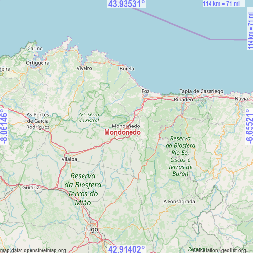
Mondoñedo GPS coordinates[2]
43° 25' 36.552" North, 7° 21' 29.988" West
| Map corner | latitude | longitude |
|---|---|---|
| Upper-left | 43.93531°, | -8.06146° |
| Center: | 43.42682°, | -7.35833° |
| Lower-right: | 42.91402°, | -6.65521° |
| Map W x H: | 113.6×113.6 km | = 70.6×70.6mi |
| max Lat: | 43.74134° ⇑1% North |
| Mondoñedo: | 43.42682° |
| min Lat: | ⇓99% South 27.64134° |
| min Long | Mondoñedo | max Long |
| -18.00367° | -7.35833° | 4.2899° |
| W 4.8%⇐ | ⇒95.2% E |
Elevation
Elevation of Mondoñedo is 113 m = 371 ft, and this is 485 m = 1591 ft below average elevation for this country.
| Max E: |
1682 m = 5518 ft | 86.8% |
| Avg. | 598 m = 1962 ft | |
| Mondoñedo | 113 m = 371 ft | |
Min E: |
0 m = 0 ft | 13.2% |
See also: Spain elevation on elevation.city.
Geographical zone
Mondoñedo is located in North temperate zone (between Tropic of Cancer and the Arctic Circle). Distance of this Northern Tropic circle is 2222.7 km =1381.1 mi to South.| Distance of | km | miles | from Mondoñedo |
|---|---|---|---|
| North Pole | 5178.5 | 3217.8 | to North |
| Arctic Circle | 2572.6 | 1598.5 | to North |
| Tropic Cancer | 2222.7 | 1381.1 | to South |
| Equator | 4828.6 | 3000.4 | to South |


Nearby cities:
15 places around Mondoñedo: (largest is in red/bold)
• Abadín
12.1 km =7.5 mi,  236°
236°
• Barreiros
15.5 km =9.6 mi,  40°
40°
• Burela de Cabo
25 km =15.5 mi,  352°
352°
• Castro de Rei
24.5 km =15.2 mi,  187°
187°
• Cervo
27.4 km =17 mi, 351°
• Foz
17.9 km =11.1 mi,  27°
27°
• Meira
24.3 km =15.1 mi,  167°
167°
• Mondoñedo
4.5 km =2.8 mi,  228°
228°
• Puente Nuevo
15.8 km =9.8 mi,  123°
123°
• Ribadeo
28.4 km =17.6 mi,  64°
64°
• Ríotorto
13.2 km =8.2 mi,  130°
130°
• San Tirso de Abres
17.5 km =10.9 mi,  96°
96°
• Taramundi
21.5 km =13.4 mi,  110°
110°
• Trabada
13.3 km =8.3 mi,  81°
81°
• Vegadeo
25 km =15.5 mi, 79°
Sources, notices
• [Note1] Compared only with cities in Spain existing in our database
• [Src1] Map data: © OpenStreetMap contributors (CC-BY-SA)
• [Src2] Other city data from geonames.org with taken over terms of usage.
• [Src3] Geographical zone / Annual Mean Temperature by Robert A. Rohde @ Wikipedia
