Sudanell geodata
Sudanell (Catalonia) is a populated place; located in Spain in Europe/Madrid (GMT+2) time zone. With population of 805 people, there are 3197 cities with bigger population in this country. Compared to other cities in Spain, 62.4% of cities are located further ↓South; 89.2% of cities are located further ←West and 83.8% of cities have higher elevation than Sudanell. Note1


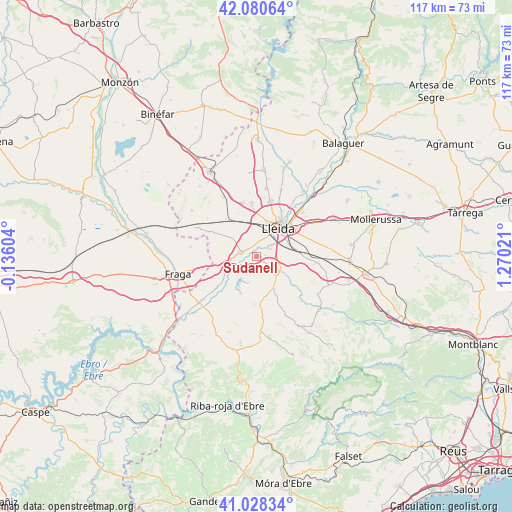
Sudanell GPS coordinates[2]
41° 33' 23.868" North, 0° 34' 1.488" East
| Map corner | latitude | longitude |
|---|---|---|
| Upper-left | 42.08064°, | -0.13604° |
| Center: | 41.55663°, | 0.56708° |
| Lower-right: | 41.02834°, | 1.27021° |
| Map W x H: | 117×117 km | = 72.7×72.7mi |
| max Lat: | 43.74134° ⇑37.6% North |
| Sudanell: | 41.55663° |
| min Lat: | ⇓62.4% South 27.64134° |
| min Long | Sudanell | max Long |
| -18.00367° | 0.56708° | 4.2899° |
| W 89.2%⇐ | ⇒10.8% E |
Elevation
Elevation of Sudanell is 158 m = 518 ft, and this is 440 m = 1444 ft below average elevation for this country.
| Max E: |
1682 m = 5518 ft | 83.8% |
| Avg. | 598 m = 1962 ft | |
| Sudanell | 158 m = 518 ft | |
Min E: |
0 m = 0 ft | 16.2% |
See also: Spain elevation on elevation.city.
Geographical zone
Sudanell is located in North temperate zone (between Tropic of Cancer and the Arctic Circle). Distance of this Northern Tropic circle is 2014.7 km =1251.9 mi to South.| Distance of | km | miles | from Sudanell |
|---|---|---|---|
| North Pole | 5386.4 | 3347 | to North |
| Arctic Circle | 2780.5 | 1727.7 | to North |
| Tropic Cancer | 2014.7 | 1251.9 | to South |
| Equator | 4620.7 | 2871.2 | to South |


Nearby cities:
15 places around Sudanell: (largest is in red/bold)
• Aitona
11.7 km =7.3 mi,  225°
225°
• Alcanó
9.4 km =5.8 mi,  153°
153°
• Alcarràs
4.3 km =2.7 mi,  284°
284°
• Alcoletge
14.6 km =9.1 mi,  46°
46°
• Alfés
5.9 km =3.7 mi,  131°
131°
• Alpicat
12.2 km =7.6 mi,  355°
355°
• Aspa
11.2 km =7 mi, 128°
• Lleida
8.1 km =5 mi,  34°
34°
• Seròs
16 km =9.9 mi, 231°
• Soses
7.4 km =4.6 mi,  249°
249°
• Sunyer
4.3 km =2.7 mi, 151°
• Torrebesses
14 km =8.7 mi,  168°
168°
• Torrefarrera
13.4 km =8.3 mi,  14°
14°
• Torres de Segre
5.1 km =3.2 mi,  240°
240°
• el Cogul
13.9 km =8.6 mi,  135°
135°
Sources, notices
• [Note1] Compared only with cities in Spain existing in our database
• [Src1] Map data: © OpenStreetMap contributors (CC-BY-SA)
• [Src2] Other city data from geonames.org with taken over terms of usage.
• [Src3] Geographical zone / Annual Mean Temperature by Robert A. Rohde @ Wikipedia
