Alpicat geodata
Alpicat (Catalonia) is a populated place; located in Spain in Europe/Madrid (GMT+2) time zone. With population of 5,020 people, there are 1299 cities with bigger population in this country. Compared to other cities in Spain, 65.1% of cities are located further ↓South; 89.2% of cities are located further ←West and 77.7% of cities have higher elevation than Alpicat. Note1


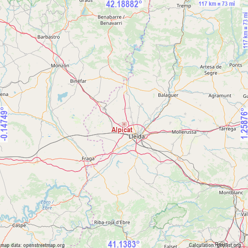
Alpicat GPS coordinates[2]
41° 39' 56.52" North, 0° 33' 20.304" East
| Map corner | latitude | longitude |
|---|---|---|
| Upper-left | 42.18882°, | -0.14749° |
| Center: | 41.6657°, | 0.55564° |
| Lower-right: | 41.1383°, | 1.25876° |
| Map W x H: | 116.8×116.8 km | = 72.6×72.6mi |
| max Lat: | 43.74134° ⇑34.9% North |
| Alpicat: | 41.6657° |
| min Lat: | ⇓65.1% South 27.64134° |
| min Long | Alpicat | max Long |
| -18.00367° | 0.55564° | 4.2899° |
| W 89.2%⇐ | ⇒10.8% E |
Elevation
Elevation of Alpicat is 260 m = 853 ft, and this is 338 m = 1109 ft below average elevation for this country.
| Max E: |
1682 m = 5518 ft | 77.7% |
| Avg. | 598 m = 1962 ft | |
| Alpicat | 260 m = 853 ft | |
Min E: |
0 m = 0 ft | 22.3% |
See also: Spain elevation on elevation.city.
Geographical zone
Alpicat is located in North temperate zone (between Tropic of Cancer and the Arctic Circle). Distance of this Northern Tropic circle is 2026.9 km =1259.5 mi to South.| Distance of | km | miles | from Alpicat |
|---|---|---|---|
| North Pole | 5374.3 | 3339.4 | to North |
| Arctic Circle | 2768.4 | 1720.2 | to North |
| Tropic Cancer | 2026.9 | 1259.5 | to South |
| Equator | 4632.8 | 2878.7 | to South |


Nearby cities:
15 places around Alpicat: (largest is in red/bold)
• Albesa
13 km =8.1 mi,  41°
41°
• Alcarràs
11.5 km =7.1 mi,  196°
196°
• Alcoletge
11.7 km =7.3 mi,  99°
99°
• Alfarràs
16.9 km =10.5 mi,  7°
7°
• Alguaire
8.3 km =5.2 mi,  16°
16°
• Almacelles
12.3 km =7.6 mi,  306°
306°
• Almenar
14.5 km =9 mi,  4°
4°
• Corbins
12.1 km =7.5 mi,  80°
80°
• Lleida
7.8 km =4.8 mi,  134°
134°
• Soses
15.9 km =9.9 mi, 202°
• Sudanell
12.2 km =7.6 mi,  175°
175°
• Sunyer
16.2 km =10.1 mi,  169°
169°
• Torrefarrera
4.3 km =2.7 mi, 78°
• Torres de Segre
15 km =9.3 mi,  193°
193°
• Vilanova de Segrià
7.6 km =4.7 mi, 41°
Sources, notices
• [Note1] Compared only with cities in Spain existing in our database
• [Src1] Map data: © OpenStreetMap contributors (CC-BY-SA)
• [Src2] Other city data from geonames.org with taken over terms of usage.
• [Src3] Geographical zone / Annual Mean Temperature by Robert A. Rohde @ Wikipedia
