Alcanó geodata
Alcanó (Catalonia) is a seat of a third-order administrative division; located in Spain in Europe/Madrid (GMT+2) time zone. With population of 251 people, there are 4734 cities with bigger population in this country. Compared to other cities in Spain, 60.4% of cities are located further ↓South; 89.4% of cities are located further ←West and 79.9% of cities have higher elevation than Alcanó. Note1


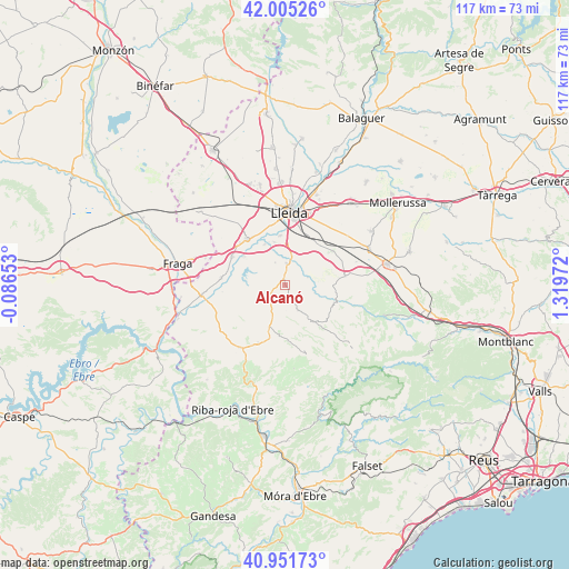
Alcanó GPS coordinates[2]
41° 28' 50.304" North, 0° 36' 59.724" East
| Map corner | latitude | longitude |
|---|---|---|
| Upper-left | 42.00526°, | -0.08653° |
| Center: | 41.48064°, | 0.61659° |
| Lower-right: | 40.95173°, | 1.31972° |
| Map W x H: | 117.1×117.1 km | = 72.8×72.8mi |
| max Lat: | 43.74134° ⇑39.6% North |
| Alcanó: | 41.48064° |
| min Lat: | ⇓60.4% South 27.64134° |
| min Long | Alcanó | max Long |
| -18.00367° | 0.61659° | 4.2899° |
| W 89.4%⇐ | ⇒10.6% E |
Elevation
Elevation of Alcanó is 221 m = 725 ft, and this is 377 m = 1237 ft below average elevation for this country.
| Max E: |
1682 m = 5518 ft | 79.9% |
| Avg. | 598 m = 1962 ft | |
| Alcanó | 221 m = 725 ft | |
Min E: |
0 m = 0 ft | 20.1% |
See also: Spain elevation on elevation.city.
Geographical zone
Alcanó is located in North temperate zone (between Tropic of Cancer and the Arctic Circle). Distance of this Northern Tropic circle is 2006.3 km =1246.7 mi to South.| Distance of | km | miles | from Alcanó |
|---|---|---|---|
| North Pole | 5394.8 | 3352.2 | to North |
| Arctic Circle | 2789 | 1733 | to North |
| Tropic Cancer | 2006.3 | 1246.7 | to South |
| Equator | 4612.2 | 2865.9 | to South |


Nearby cities:
15 places around Alcanó: (largest is in red/bold)
• Aitona
12.5 km =7.8 mi,  271°
271°
• Alcarràs
12.7 km =7.9 mi,  318°
318°
• Alfés
4.5 km =2.8 mi,  4°
4°
• Aspa
4.9 km =3 mi,  71°
71°
• Castelldans
12.7 km =7.9 mi,  80°
80°
• Llardecáns
13.1 km =8.1 mi,  205°
205°
• Lleida
15.1 km =9.4 mi, 1°
• Maials
16 km =9.9 mi,  217°
217°
• Soses
12.5 km =7.8 mi,  297°
297°
• Sudanell
9.4 km =5.8 mi,  333°
333°
• Sunyer
5.1 km =3.2 mi,  336°
336°
• Torrebesses
5.4 km =3.4 mi,  194°
194°
• Torres de Segre
10.4 km =6.5 mi, 304°
• el Cogul
5.8 km =3.6 mi,  105°
105°
• la Granadella
15.1 km =9.4 mi,  163°
163°
Sources, notices
• [Note1] Compared only with cities in Spain existing in our database
• [Src1] Map data: © OpenStreetMap contributors (CC-BY-SA)
• [Src2] Other city data from geonames.org with taken over terms of usage.
• [Src3] Geographical zone / Annual Mean Temperature by Robert A. Rohde @ Wikipedia
