Huertahernando geodata
Huertahernando (Castille-La Mancha) is a seat of a third-order administrative division; located in Spain in Europe/Madrid (GMT+2) time zone. With population of 66 people, there are 6282 cities with bigger population in this country. Compared to other cities in Spain, 55.6% of cities are located further ↑North; 63.6% of cities are located further ←West and 95.5% of cities have lower elevation than Huertahernando. Note1
Administrative division(s):
- Level 1: Castille-La Mancha
- Level 2: Provincia de Guadalajara
- Level 3: Huertahernando


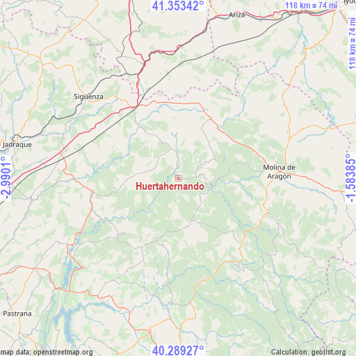
Huertahernando GPS coordinates[2]
40° 49' 24.528" North, 2° 17' 13.092" West
| Map corner | latitude | longitude |
|---|---|---|
| Upper-left | 41.35342°, | -2.9901° |
| Center: | 40.82348°, | -2.28697° |
| Lower-right: | 40.28927°, | -1.58385° |
| Map W x H: | 118.3×118.3 km | = 73.5×73.5mi |
| max Lat: | 43.74134° ⇑55.6% North |
| Huertahernando: | 40.82348° |
| min Lat: | ⇓44.4% South 27.64134° |
| min Long | Huertahernando | max Long |
| -18.00367° | -2.28697° | 4.2899° |
| W 63.6%⇐ | ⇒36.4% E |
Elevation
Elevation of Huertahernando is 1151 m = 3776 ft, and this is 553 m = 1814 ft above average elevation for this country.
| Max E: |
1682 m = 5518 ft | 4.5% |
| Huertahernando | 1151 m 3776 ft | |
| Avg. | 598 m = 1962 ft | |
Min E: |
0 m = 0 ft | 95.5% |
See also: Spain elevation on elevation.city.
Geographical zone
Huertahernando is located in North temperate zone (between Tropic of Cancer and the Arctic Circle). Distance of this Northern Tropic circle is 1933.2 km =1201.2 mi to South.| Distance of | km | miles | from Huertahernando |
|---|---|---|---|
| North Pole | 5467.9 | 3397.6 | to North |
| Arctic Circle | 2862 | 1778.4 | to North |
| Tropic Cancer | 1933.2 | 1201.2 | to South |
| Equator | 4539.1 | 2820.5 | to South |


Nearby cities:
15 places around Huertahernando: (largest is in red/bold)
• Ablanque
9.8 km =6.1 mi,  32°
32°
• Abánades
18.4 km =11.4 mi,  294°
294°
• Armallones
9.8 km =6.1 mi,  187°
187°
• Canredondo
17.4 km =10.8 mi,  266°
266°
• Cobeta
13.1 km =8.1 mi,  68°
68°
• Esplegares
8 km =5 mi,  297°
297°
• Ocentejo
10.9 km =6.8 mi,  238°
238°
• Olmeda de Cobeta
9.6 km =6 mi, 65°
• Riba de Saelices
9.8 km =6.1 mi,  354°
354°
• Sacecorbo
11.1 km =6.9 mi,  275°
275°
• Saelices de la Sal
9.8 km =6.1 mi,  341°
341°
• Sotodosos
14 km =8.7 mi,  320°
320°
• Valtablado del Río
15.6 km =9.7 mi,  218°
218°
• Villanueva de Alcorón
16.3 km =10.1 mi,  169°
169°
• Zaorejas
9.9 km =6.2 mi,  133°
133°
Sources, notices
• [Note1] Compared only with cities in Spain existing in our database
• [Src1] Map data: © OpenStreetMap contributors (CC-BY-SA)
• [Src2] Other city data from geonames.org with taken over terms of usage.
• [Src3] Geographical zone / Annual Mean Temperature by Robert A. Rohde @ Wikipedia
