Salas geodata
Salas (Asturias) is a seat of a third-order administrative division; located in Spain in Europe/Madrid (GMT+2) time zone. With population of 6,350 people, there are 1095 cities with bigger population in this country. Compared to other cities in Spain, 99% of cities are located further ↓South; 89.1% of cities are located further →East and 75% of cities have higher elevation than Salas. Note1


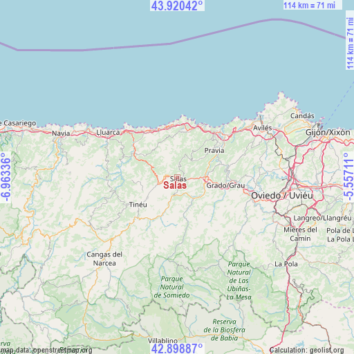
Salas GPS coordinates[2]
43° 24' 42.48" North, 6° 15' 36.828" West
| Map corner | latitude | longitude |
|---|---|---|
| Upper-left | 43.92042°, | -6.96336° |
| Center: | 43.4118°, | -6.26023° |
| Lower-right: | 42.89887°, | -5.55711° |
| Map W x H: | 113.6×113.6 km | = 70.6×70.6mi |
| max Lat: | 43.74134° ⇑1% North |
| Salas: | 43.4118° |
| min Lat: | ⇓99% South 27.64134° |
| min Long | Salas | max Long |
| -18.00367° | -6.26023° | 4.2899° |
| W 10.9%⇐ | ⇒89.1% E |
Elevation
Elevation of Salas is 297 m = 974 ft, and this is 301 m = 988 ft below average elevation for this country.
| Max E: |
1682 m = 5518 ft | 75% |
| Avg. | 598 m = 1962 ft | |
| Salas | 297 m = 974 ft | |
Min E: |
0 m = 0 ft | 25% |
See also: Spain elevation on elevation.city.
Geographical zone
Salas is located in North temperate zone (between Tropic of Cancer and the Arctic Circle). Distance of this Northern Tropic circle is 2221 km =1380.1 mi to South.| Distance of | km | miles | from Salas |
|---|---|---|---|
| North Pole | 5180.1 | 3218.8 | to North |
| Arctic Circle | 2574.2 | 1599.5 | to North |
| Tropic Cancer | 2221 | 1380.1 | to South |
| Equator | 4826.9 | 2999.3 | to South |


Nearby cities:
15 places around Salas: (largest is in red/bold)
• Belmonte
14.8 km =9.2 mi,  166°
166°
• Castrillón
26.3 km =16.3 mi,  54°
54°
• Cudillero
19.1 km =11.9 mi,  28°
28°
• Grado
15.2 km =9.4 mi,  99°
99°
• Illas
24.9 km =15.5 mi,  67°
67°
• Llanera
27.2 km =16.9 mi,  78°
78°
• Muros de Nalón
19.3 km =12 mi,  40°
40°
• Piedras Blancas
28.2 km =17.5 mi, 54°
• Pravia
14.7 km =9.1 mi, 54°
• Proaza
26.6 km =16.5 mi,  132°
132°
• Ranón
22.3 km =13.9 mi, 44°
• San Esteban de Pravia
21.1 km =13.1 mi, 41°
• San Juan de la Arena
22.2 km =13.8 mi, 42°
• Soto del Barco
20.4 km =12.7 mi, 48°
• Tineo
14.9 km =9.3 mi,  236°
236°
Sources, notices
• [Note1] Compared only with cities in Spain existing in our database
• [Src1] Map data: © OpenStreetMap contributors (CC-BY-SA)
• [Src2] Other city data from geonames.org with taken over terms of usage.
• [Src3] Geographical zone / Annual Mean Temperature by Robert A. Rohde @ Wikipedia
