Sotillo geodata
Sotillo (Castille and León) is a seat of a third-order administrative division; located in Spain in Europe/Madrid (GMT+2) time zone. With population of 38 people, there are 6589 cities with bigger population in this country. Compared to other cities in Spain, 54.5% of cities are located further ↓South; 54.3% of cities are located further →East and 87.3% of cities have lower elevation than Sotillo. Note1
Administrative division(s):
- Level 1: Castille and León
- Level 2: Provincia de Segovia
- Level 3: Sotillo


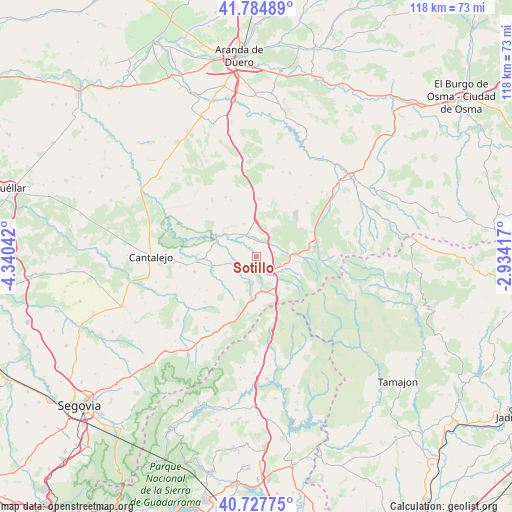
Sotillo GPS coordinates[2]
41° 15' 30.456" North, 3° 38' 14.244" West
| Map corner | latitude | longitude |
|---|---|---|
| Upper-left | 41.78489°, | -4.34042° |
| Center: | 41.25846°, | -3.63729° |
| Lower-right: | 40.72775°, | -2.93417° |
| Map W x H: | 117.5×117.5 km | = 73×73mi |
| max Lat: | 43.74134° ⇑45.5% North |
| Sotillo: | 41.25846° |
| min Lat: | ⇓54.5% South 27.64134° |
| min Long | Sotillo | max Long |
| -18.00367° | -3.63729° | 4.2899° |
| W 45.7%⇐ | ⇒54.3% E |
Elevation
Elevation of Sotillo is 986 m = 3235 ft, and this is 388 m = 1273 ft above average elevation for this country.
| Max E: |
1682 m = 5518 ft | 12.7% |
| Sotillo | 986 m 3235 ft | |
| Avg. | 598 m = 1962 ft | |
Min E: |
0 m = 0 ft | 87.3% |
See also: Spain elevation on elevation.city.
Geographical zone
Sotillo is located in North temperate zone (between Tropic of Cancer and the Arctic Circle). Distance of this Northern Tropic circle is 1981.6 km =1231.3 mi to South.| Distance of | km | miles | from Sotillo |
|---|---|---|---|
| North Pole | 5419.6 | 3367.6 | to North |
| Arctic Circle | 2813.7 | 1748.4 | to North |
| Tropic Cancer | 1981.6 | 1231.3 | to South |
| Equator | 4587.5 | 2850.5 | to South |


Nearby cities:
15 places around Sotillo: (largest is in red/bold)
• Aldealcorvo
13 km =8.1 mi,  263°
263°
• Aldeonte
10.8 km =6.7 mi,  341°
341°
• Barbolla
8.1 km =5 mi, 337°
• Boceguillas
8.7 km =5.4 mi,  359°
359°
• Casla
10.4 km =6.5 mi,  188°
188°
• Castillejo de Mesleón
3.9 km =2.4 mi,  50°
50°
• Castroserna de Abajo
9.8 km =6.1 mi,  235°
235°
• Cerezo de Abajo
5.9 km =3.7 mi,  139°
139°
• Cerezo de Arriba
6.9 km =4.3 mi,  108°
108°
• Duruelo
2.7 km =1.7 mi,  201°
201°
• Encinas
13.2 km =8.2 mi,  348°
348°
• Grajera
12.9 km =8 mi,  9°
9°
• Riaza
13.5 km =8.4 mi,  80°
80°
• Santa Marta del Cerro
6 km =3.7 mi,  222°
222°
• Sepúlveda
9.8 km =6.1 mi,  296°
296°
Sources, notices
• [Note1] Compared only with cities in Spain existing in our database
• [Src1] Map data: © OpenStreetMap contributors (CC-BY-SA)
• [Src2] Other city data from geonames.org with taken over terms of usage.
• [Src3] Geographical zone / Annual Mean Temperature by Robert A. Rohde @ Wikipedia
