Castillejo de Mesleón geodata
Castillejo de Mesleón (Castille and León) is a seat of a third-order administrative division; located in Spain in Europe/Madrid (GMT+2) time zone. With population of 153 people, there are 5403 cities with bigger population in this country. Compared to other cities in Spain, 55% of cities are located further ↓South; 53.7% of cities are located further →East and 88.8% of cities have lower elevation than Castillejo de Mesleón. Note1
Administrative division(s):
- Level 1: Castille and León
- Level 2: Provincia de Segovia
- Level 3: Castillejo de Mesleón


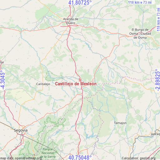
Castillejo de Mesleón GPS coordinates[2]
41° 16' 51.6" North, 3° 36' 4.932" West
| Map corner | latitude | longitude |
|---|---|---|
| Upper-left | 41.80725°, | -4.3045° |
| Center: | 41.281°, | -3.60137° |
| Lower-right: | 40.75048°, | -2.89825° |
| Map W x H: | 117.5×117.5 km | = 73×73mi |
| max Lat: | 43.74134° ⇑45% North |
| Castillejo de Mesleón: | 41.281° |
| min Lat: | ⇓55% South 27.64134° |
| min Long | Castillejo de M | max Long |
| -18.00367° | -3.60137° | 4.2899° |
| W 46.3%⇐ | ⇒53.7% E |
Elevation
Elevation of Castillejo de Mesleón is 1010 m = 3314 ft, and this is 412 m = 1352 ft above average elevation for this country.
| Max E: |
1682 m = 5518 ft | 11.2% |
| Castillejo de Mesleón | 1010 m 3314 ft | |
| Avg. | 598 m = 1962 ft | |
Min E: |
0 m = 0 ft | 88.8% |
See also: Spain elevation on elevation.city.
Geographical zone
Castillejo de Mesleón is located in North temperate zone (between Tropic of Cancer and the Arctic Circle). Distance of this Northern Tropic circle is 1984.1 km =1232.9 mi to South.| Distance of | km | miles | from Castillejo de Mesleón |
|---|---|---|---|
| North Pole | 5417 | 3366 | to North |
| Arctic Circle | 2811.2 | 1746.8 | to North |
| Tropic Cancer | 1984.1 | 1232.9 | to South |
| Equator | 4590 | 2852.1 | to South |


Nearby cities:
15 places around Castillejo de Mesleón: (largest is in red/bold)
• Aldeonte
10.1 km =6.3 mi,  320°
320°
• Barbolla
7.8 km =4.8 mi,  309°
309°
• Boceguillas
6.9 km =4.3 mi,  333°
333°
• Cerezo de Abajo
7 km =4.3 mi,  173°
173°
• Cerezo de Arriba
5.9 km =3.7 mi,  142°
142°
• Duruelo
6.4 km =4 mi,  218°
218°
• Encinas
11.8 km =7.3 mi, 332°
• Fresno de Cantespino
12.9 km =8 mi,  41°
41°
• Grajera
10.3 km =6.4 mi,  354°
354°
• Pajarejos
12.2 km =7.6 mi,  4°
4°
• Riaza
10.3 km =6.4 mi,  91°
91°
• Santa Marta del Cerro
9.9 km =6.2 mi,  225°
225°
• Sepúlveda
11.9 km =7.4 mi,  278°
278°
• Sequera de Fresno
10.6 km =6.6 mi,  25°
25°
• Sotillo
3.9 km =2.4 mi, 230°
Sources, notices
• [Note1] Compared only with cities in Spain existing in our database
• [Src1] Map data: © OpenStreetMap contributors (CC-BY-SA)
• [Src2] Other city data from geonames.org with taken over terms of usage.
• [Src3] Geographical zone / Annual Mean Temperature by Robert A. Rohde @ Wikipedia
