Riaza geodata
Riaza (Castille and León) is a seat of a third-order administrative division; located in Spain in Europe/Madrid (GMT+2) time zone. With population of 2,054 people, there are 2128 cities with bigger population in this country. Compared to other cities in Spain, 54.9% of cities are located further ↓South; 51.7% of cities are located further →East and 96.8% of cities have lower elevation than Riaza. Note1


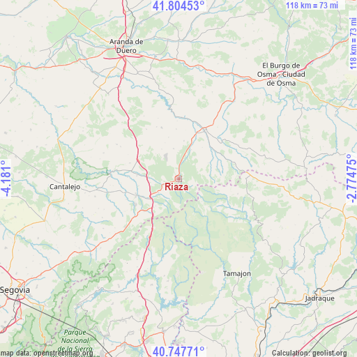
Riaza GPS coordinates[2]
41° 16' 41.736" North, 3° 28' 40.332" West
| Map corner | latitude | longitude |
|---|---|---|
| Upper-left | 41.80453°, | -4.181° |
| Center: | 41.27826°, | -3.47787° |
| Lower-right: | 40.74771°, | -2.77475° |
| Map W x H: | 117.5×117.5 km | = 73×73mi |
| max Lat: | 43.74134° ⇑45.1% North |
| Riaza: | 41.27826° |
| min Lat: | ⇓54.9% South 27.64134° |
| min Long | Riaza | max Long |
| -18.00367° | -3.47787° | 4.2899° |
| W 48.3%⇐ | ⇒51.7% E |
Elevation
Elevation of Riaza is 1199 m = 3934 ft, and this is 601 m = 1972 ft above average elevation for this country.
| Max E: |
1682 m = 5518 ft | 3.2% |
| Riaza | 1199 m 3934 ft | |
| Avg. | 598 m = 1962 ft | |
Min E: |
0 m = 0 ft | 96.8% |
See also: Spain elevation on elevation.city.
Geographical zone
Riaza is located in North temperate zone (between Tropic of Cancer and the Arctic Circle). Distance of this Northern Tropic circle is 1983.8 km =1232.7 mi to South.| Distance of | km | miles | from Riaza |
|---|---|---|---|
| North Pole | 5417.3 | 3366.2 | to North |
| Arctic Circle | 2811.5 | 1747 | to North |
| Tropic Cancer | 1983.8 | 1232.7 | to South |
| Equator | 4589.7 | 2851.9 | to South |


Nearby cities:
15 places around Riaza: (largest is in red/bold)
• Barbolla
17.2 km =10.7 mi,  287°
287°
• Bercimuel
15.5 km =9.6 mi,  330°
330°
• Boceguillas
14.9 km =9.3 mi,  295°
295°
• Castillejo de Mesleón
10.3 km =6.4 mi,  271°
271°
• Cerezo de Abajo
11.6 km =7.2 mi,  234°
234°
• Cerezo de Arriba
8 km =5 mi,  236°
236°
• Corral de Ayllón
12.6 km =7.8 mi,  7°
7°
• Duruelo
15.1 km =9.4 mi,  251°
251°
• Fresno de Cantespino
10.2 km =6.3 mi,  349°
349°
• Grajera
15.5 km =9.6 mi,  313°
313°
• Pajarejos
15.5 km =9.6 mi,  322°
322°
• Riaguas de San Bartolomé
16.5 km =10.3 mi,  356°
356°
• Ribota
10.4 km =6.5 mi,  22°
22°
• Sequera de Fresno
11.3 km =7 mi, 329°
• Sotillo
13.5 km =8.4 mi,  260°
260°
Sources, notices
• [Note1] Compared only with cities in Spain existing in our database
• [Src1] Map data: © OpenStreetMap contributors (CC-BY-SA)
• [Src2] Other city data from geonames.org with taken over terms of usage.
• [Src3] Geographical zone / Annual Mean Temperature by Robert A. Rohde @ Wikipedia
