Portugalete geodata
Portugalete (Basque Country) is a seat of a third-order administrative division; located in Spain in Europe/Madrid (GMT+2) time zone. With population of 48,105 people, there are 186 cities with bigger population in this country. Compared to other cities in Spain, 97.9% of cities are located further ↓South; 54% of cities are located further ←West and 91.3% of cities have higher elevation than Portugalete. Note1


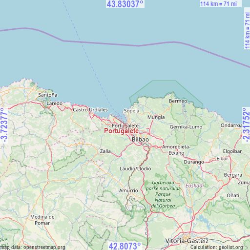
Portugalete GPS coordinates[2]
43° 19' 15.564" North, 3° 1' 14.304" West
| Map corner | latitude | longitude |
|---|---|---|
| Upper-left | 43.83037°, | -3.72377° |
| Center: | 43.32099°, | -3.02064° |
| Lower-right: | 42.8073°, | -2.31752° |
| Map W x H: | 113.8×113.8 km | = 70.7×70.7mi |
| max Lat: | 43.74134° ⇑2.1% North |
| Portugalete: | 43.32099° |
| min Lat: | ⇓97.9% South 27.64134° |
| min Long | Portugalete | max Long |
| -18.00367° | -3.02064° | 4.2899° |
| W 54%⇐ | ⇒46% E |
Elevation
Elevation of Portugalete is 49 m = 161 ft, and this is 549 m = 1801 ft below average elevation for this country.
| Max E: |
1682 m = 5518 ft | 91.3% |
| Avg. | 598 m = 1962 ft | |
| Portugalete | 49 m = 161 ft | |
Min E: |
0 m = 0 ft | 8.7% |
See also: Portugalete elevation on elevation.city.
Geographical zone
Portugalete is located in North temperate zone (between Tropic of Cancer and the Arctic Circle). Distance of this Northern Tropic circle is 2210.9 km =1373.8 mi to South.| Distance of | km | miles | from Portugalete |
|---|---|---|---|
| North Pole | 5190.2 | 3225 | to North |
| Arctic Circle | 2584.3 | 1605.8 | to North |
| Tropic Cancer | 2210.9 | 1373.8 | to South |
| Equator | 4816.8 | 2993 | to South |


Nearby cities:
15 places around Portugalete: (largest is in red/bold)
• Algorta
3.3 km =2.1 mi,  16°
16°
• Alonsotegi
8.9 km =5.5 mi,  162°
162°
• Barakaldo
3.8 km =2.4 mi,  136°
136°
• Berango
5.3 km =3.3 mi, 22°
• Erandio
4.2 km =2.6 mi,  115°
115°
• Erandiogoikoa
5.6 km =3.5 mi,  105°
105°
• Getxo
4.1 km =2.5 mi,  10°
10°
• Leioa
2.7 km =1.7 mi,  75°
75°
• Ortuella
3.1 km =1.9 mi,  249°
249°
• San Julián de Muskiz
6.6 km =4.1 mi,  282°
282°
• Santurtzi
1.3 km =0.8 mi,  310°
310°
• Sestao
1.7 km =1.1 mi, 138°
• Sondika
8.1 km =5 mi, 106°
• Sopela
7.1 km =4.4 mi,  25°
25°
• Zierbena
6 km =3.7 mi,  302°
302°
Sources, notices
• [Note1] Compared only with cities in Spain existing in our database
• [Src1] Map data: © OpenStreetMap contributors (CC-BY-SA)
• [Src2] Other city data from geonames.org with taken over terms of usage.
• [Src3] Geographical zone / Annual Mean Temperature by Robert A. Rohde @ Wikipedia
