Zierbena geodata
Zierbena (Basque Country) is a seat of a third-order administrative division; located in Spain in Europe/Madrid (GMT+2) time zone. With population of 9,418 people, there are 880 cities with bigger population in this country. Compared to other cities in Spain, 98.2% of cities are located further ↓South; 53% of cities are located further ←West and 91.6% of cities have higher elevation than Zierbena. Note1


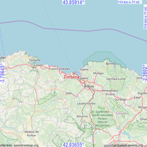
Zierbena GPS coordinates[2]
43° 21' 0" North, 3° 4' 59.988" West
| Map corner | latitude | longitude |
|---|---|---|
| Upper-left | 43.85914°, | -3.78645° |
| Center: | 43.35°, | -3.08333° |
| Lower-right: | 42.83655°, | -2.3802° |
| Map W x H: | 113.7×113.7 km | = 70.6×70.6mi |
| max Lat: | 43.74134° ⇑1.8% North |
| Zierbena: | 43.35° |
| min Lat: | ⇓98.2% South 27.64134° |
| min Long | Zierbena | max Long |
| -18.00367° | -3.08333° | 4.2899° |
| W 53%⇐ | ⇒47% E |
Elevation
Elevation of Zierbena is 46 m = 151 ft, and this is 552 m = 1811 ft below average elevation for this country.
| Max E: |
1682 m = 5518 ft | 91.6% |
| Avg. | 598 m = 1962 ft | |
| Zierbena | 46 m = 151 ft | |
Min E: |
0 m = 0 ft | 8.4% |
See also: Spain elevation on elevation.city.
Geographical zone
Zierbena is located in North temperate zone (between Tropic of Cancer and the Arctic Circle). Distance of this Northern Tropic circle is 2214.1 km =1375.8 mi to South.| Distance of | km | miles | from Zierbena |
|---|---|---|---|
| North Pole | 5187 | 3223.1 | to North |
| Arctic Circle | 2581.1 | 1603.8 | to North |
| Tropic Cancer | 2214.1 | 1375.8 | to South |
| Equator | 4820.1 | 2995.1 | to South |


Nearby cities:
15 places around Zierbena: (largest is in red/bold)
• Algorta
6 km =3.7 mi,  90°
90°
• Barakaldo
9.7 km =6 mi,  127°
127°
• Berango
7.3 km =4.5 mi,  76°
76°
• Erandio
10.2 km =6.3 mi,  119°
119°
• Getxo
5.9 km =3.7 mi, 82°
• Landa
11.4 km =7.1 mi,  71°
71°
• Leioa
8.1 km =5 mi,  108°
108°
• Ortuella
4.8 km =3 mi,  153°
153°
• Portugalete
6 km =3.7 mi, 122°
• San Julián de Muskiz
2.3 km =1.4 mi,  216°
216°
• San Pedro Galdames
11.2 km =7 mi,  186°
186°
• Santurtzi
4.8 km =3 mi, 120°
• Sestao
7.6 km =4.7 mi, 125°
• Sopela
8.7 km =5.4 mi, 68°
• Sopuerta
11.3 km =7 mi,  210°
210°
Sources, notices
• [Note1] Compared only with cities in Spain existing in our database
• [Src1] Map data: © OpenStreetMap contributors (CC-BY-SA)
• [Src2] Other city data from geonames.org with taken over terms of usage.
• [Src3] Geographical zone / Annual Mean Temperature by Robert A. Rohde @ Wikipedia
